MSU Storm Chase Class

Saturday, February 28, 2009

RADAR AND SNOW REPORTS FROM VIEWERS


Radar image as of 5:30pm...

Viewer reports:
8am---Blizzard-like conditions in Racket. Hearing lots of wrecks on scanner. 2" of snow
9am---1.25" of snow 3/4 miles south of CC and Fremont Rd.
10:50am---Lake Pomme de Terre reports 3" and still coming down
11:10am---Racket now has 4" of snow
3:00pm---9" measured in St. Robert
3:55pm---3.5" in Pomme de Terre with snow falling again
4:22pm---9 1/4" so far in Salem
5:00pm---3-5" of snow measured to the SE of Lebanon
5:06pm--- 6" just outside Osceola
5:25pm---9" in Crocker
5:30pm---9.5-10" of snow measured in Licking
8:00pm---7" Warsaw mm82 Lake of the Ozarks

Send in your reports and pictures to weatherlab@ozarksfirst.com

WINTER STORM WARNING/ADVISORY UPDATE

Arkansas remains under a WINTER WEATHER ADVISORY until 3am. If you must drive tonight, drive slowly!

Friday, February 27, 2009

The Snow of the Season!


Springfield may pick up an inch and some change, The snow amounts generally increase east of Springfield where an average of 1-3" will fall.

One band of enhanced snow will enter central Missouri and then fade a bit. A second maximum area will develop over south-central Missouri by afternoon and spread east toward the bootheel.

The snow is expected to be heaviest in southeastern Missouri later today and a Winter Storm Warning is in efect for that region.

This would be the third weekend snow in a row. Our winter season total in Springfield is 6.4" so far.

Thursday, February 26, 2009


A supercell thunderstorm began to take shape in St Clair Co during the evening of February 26th.

It had good radar structure as it moved ESE through northern Polk Co. As it entered Dallas Co., it began to show signs of stronger rotation and the National Weather Service issued a tornado warning at about 6:15 pm.

The yellow callouts are wind damge reports and the green are hail reports.

The circulation center passed south of Lebanon.

WIND REPORTS

6:20 PM: LOUISBURG,MO, DALLAS CO.

ESTIMATED 50 MPH WIND GUST

6:30 PM: 2 NW WINDYVILLE,MO, DALLAS CO.

2 FT DIAMETER TREE DOWN BETWEEN PLAD AND WINDYVILLE OFF OF HWY K.

6:38 PM: BENNETT SPRINGS,MO, LACLEDE CO.

LARGE BILLBOARD PUSHED OVER BY WINDS.

7:22 PM: 5 SE FALCON, MO, CO.

PUBLIC REPORT OF 4 INCH DIAMETER TREE LIMBS BROKEN ON HIGHWAY 32

7:25 PM, FALCON, MO, LACLEDE CO.

WIND GUST ESTIMATED TO 70 MPH

Storm Potential Update


The 5% tornado risk was expanded this afternoon to include all of the eastern half of our viewing area.
Moisture is flowing northward which will aid in the instability but a lack of sunshine is inhibiting the potential somewhat. Individual cells will have to be watched in areas to the northwest of Springfield until the early evening hours for severe tendencies.
Otherwise, a squall line will eventually form and move southeast through our area the rest of the evening. Hail and bowing segments with damaging wind potential and a small risk for tornadoes are the threats.


Tuesday, February 24, 2009

SEVERE STORM THREAT THURSDAY

Storms are forecast to form in Illinois and areas to the northeast and then build southwestward along the cold front during the late afternoon and evening hours. There is a slight risk for severe storms today. The main threats would be damaging winds and hail. The chance for an isolated tornado or two cannot be ruled out. There is still a lot of question as to whether or not supercells will even form. The greatest chance for surface-based storms is across Arkansas, except for the NW corner. We'll continue to monitor this situation as it unfolds.

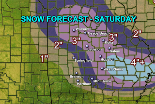
SNOW FOR THE 3RD WEEKEND IN A ROW?

The images above show total liquid forecast amounts for Saturday. Notice how the computer models do not agree on amounts but do agree on the general track of precipitation. Converting liquid amounts over to snow with each model, the general consensus is that the heaviest snow will fall east of Springfield or north.

GFS converted: 1" or less might fall in a line from Joplin to Branson to Mtn Home and points south. 2" is possible points north including Nevada, Springfield, West Plains and Osage Beach. Greater than 2" is possible in Lebanon to Rolla to Salem. Isolated amounts around 4" if possible in parts of eastern Dent and Shannon counties.

NAM converted" 1" or less is forecast across Nevada to Joplin to Branson to Mtn Home and points south. 2" is forecast to fall across Springfield to Osceola to West Plains. Greater than 2" is possible across Houston to Lebanon to Osage Beach to Warsaw.

Sunday, February 22, 2009

ACTIVE WEATHER PATTERN INTO EARLY MARCH

Looking 384 hours out from now, the weather pattern appears active though it's too difficult to figure out which day over the next 16 days that a system will move through. Models continue to hint towards a system impacting us around the 4th and another one sometime between the 7-9th of March.

Saturday, February 21, 2009

WINTER vs SPRING

A large portion of the viewing area saw a dusting of snow this morning. Parts of Christian, Greene, Webster, Dallas, Laclede, Texas and Phelps county saw .3" to .6" with isolated higher amounts to around 1" in northern Texas and southern Webster county.
This is a picture from my backyard(Feb 21, 2009) of winter fighting with spring. ;) I have a ton of bulbs coming up and it just looks odd to see a coating of snow around them. The sunshine is warm enough to melt the snow, while in the shade winter holds on strong.


Strong Tornado Sends Debris Far

An interesting presentation from the Tulsa National Weather Service Office:

http://www.srh.noaa.gov/tsa/weather-events/briefing_LoneGroveDebris/player.html

Friday, February 20, 2009

Snow Update


Snow Shot Early Saturday


A band of very light, but likely briefly intense, snow will rush through the Ozarks overnight Friday behind a strong cold front.
A dusting to perhaps a few tenths of an inch of snow may accumulate.

Wednesday, February 18, 2009

SATURDAY MORNING SNOW CHANCE


The top computer model image is a prediction of what the temperatures, winds, and pressure lines might look like during Saturday morning. I drew in a cold front and also labelled the 25, 30 and 35 degree lines. Temperatures are cold enough for snow in most places except for right along the front. Notice in the computer model image below, the precipitation output indicates .10"-.20" of liquid across Arkansas. That could translate to an inch or two of snow with lighter amounts possible across southern Missouri. It appears as if there is a chance for rain showers transitioning over to snow showers across Arkansas and southern Missouri on Saturday morning. A dusting up to and inch is possible. If the track of the low changes from what the model is predicting for that time frame, then the snow may miss the southern portion of the Ozarks. Keep checking the blog for further updates or watch KOLR10 and KSFX News.

Tuesday, February 17, 2009

Thunderstorm Line

The line of storms producing small hail is racing northeast at about 50 mph. Expect occasional hail from 3/4 to 1" in diameter east of a line from Harrison AR to Eminence MO tonight.

Meso Update #1


Radar at 10:00 pm 2/17
Severe thunderstorms warning for portions of Stone (MO), Christian and Taney.
Primary threat will be hail up to 1" in diameter.

Thunderstorms with Hail


Storms have popped up in northeastern Oklahoma. Severe Thunderstorms Warning has just been extended into Benton County, AR.

These storms appear to be elevated with the primary risk hail up to one inch in diameter.

Folks in northern Arkansas and extreme southern Missouri should watch for this threat over the next several hours.

Colder Trend


We'll spend most of the days through the weekend rather chilly.
Late Wednesday will be blustery with winds out of the northwest.
A clipper low passes to the northeast Friday bring in a temporary wedge of warm air in on west winds.
The weekend turns verty chilly once again
The next storm of any meaning will approach the area Monday night.

Monday, February 16, 2009

Northeastern Storm Wednesday-Thursday


A band of heavy snow will set up over portions of the northeastern U.S. for the next few days.

Another "clipper" we be sweeping through this same area Friday.

This is part of a shift toward colder conditions for the eastern half of the country through the weekend.


Sunday, February 15, 2009

Snow Earlier Sunday


Thanks for the photo!

One of our blog followers, Jayme in Mtn Home, took a picture of the surprise snow down that way early on Sunday.

The fast-moving system was only expected to produce flurries but it did manage to squeeze out measureable snow across southern Missouri and northern Arkansas.

Wednesday, February 11, 2009

EF1 Tornado in Springfield Tuesday Night!


Well, National Weather Service surveys confirm an EF1 tornado skipped across parts of southern Springfield Tuesday night.


Thursday, February 5, 2009

Gassville, AR Tornado


This tornado was on the western edge of an outbreak of storms which has been nicknamed the "Super Tuesday Outbreak" because it occurred on a huge presidential primary night.
Gassville was hit by an EF2 tornado at about 5:10 that evening.
Another powerful EF4 tornado tore a record path through Arkansas, striking Mtn. View and Ash Flat among other locations.

I have a write-up on this storm here.