MSU Storm Chase Class

Friday, October 30, 2009

Rain, Rain, Rain


Yesterday’s rain total for Springfield was logged at 1.72″ which is a record for that date, 10/29. This has pushed our October rain total to 9.97″ or 6.75″ above a normal October!

The heaviest rain areas occurred east and southeast of Springfield and included numerous 4″ plus totals and even a few over the 5″ mark.

The National Weather Service has a complete rainfall report here.

Ted Keller
Senior Meteorologist
KOLR/KSFX-TV
Storm chasing and more at:
Ceaseless Wind

Tuesday, October 27, 2009

Late Week Storm


The story of the week is the approach of a powerful storm in the upper atmosphere, scheduled to arrive in the Thursday/Friday time frame.

The system is expected to "occlude" which means the most unstable air should stay south of the majority of the Ozarks. This should have the affect of keeping widespread severe thunderstorms either out of our area or possible south of Springfield in extreme southern Missouri or northern Arkansas.

Rainfall seems to be exploding more to our east and southeast as per the HPC rainfall forecast. Computer model forecasts for Springfield specifically are all over, ranging from only around .25" to well over 1.00". It seems as if areas most likely to skew to inches of rain would be areas to the south and southeast of Springfield.

Ted Keller
Senior Meteorologist
KOLR/KSFX-TV
Storm chasing and more at:
Ceaseless Wind

Monday, October 26, 2009

Big Storm Late Week


The system hung up over the Ozarks Monday and Tuesday is wet but rather weak.

A much stronger weather system is taking shape for Thursday and Friday, one which will bring strong, possibly severe, storms to the Ozarks along with more heavy rain.

More on this developing storm on KOLR News at 5, 6 & 10 and Fox News @ Nine!


Ted Keller
Senior Meteorologist
KOLR/KSFX-TV
Storm chasing and more at:
Ceaseless Wind

Coolest Has Ruled!

It's interesting to note that since July, every month has seen its average temperature below normal:

July: -4.3
August: -3.8
September: -2.2
October(through 25th): -7.6


I will talk more about these stats and also "reflect" on the unusual amount of rain and cloud days through this same period tonight at 5, 6 & 10 on KOLR and FOX News @ Nine!


Ted Keller
Senior Meteorologist
KOLR/KSFX-TV
Storm chasing and more at:
Ceaseless Wind

Saturday, October 17, 2009

Frost/Freeze Tonight


The clouds we've been wanting to get rid of will finally break rather quickly tonight allowing temperatures to plummet!

The center of the high where the calmest winds will be will pass over central Missouri tonight and this area is under the greatest risk for a sun-freezing low temperature. The rest of the area will likely experience a pretty good frost.

Ted Keller
Senior Meteorologist
KOLR/KSFX-TV
Storm chasing and more at:
Ceaseless Wind

Winter Outlook


The government (NOAA) has issued a forecast for the winter season. This is an El Nino year which means the waters in the equatorial eastern Pacific are unusually warm.

Every El Nino is slightly different but generally speaking, the southern storm track becomes more active especially in the western and southeastern U.S. Dry and mild air occupies much and the central and northern U.S. The centers of dry/moist warm/cold are away from the Ozarks which means we are somewhat "El Nino Neutral" with no probability of a significant pattern shift.

It should be noted that our multi-month run of below normal temperatures and slightly wet conditions seems poised to continue. Except for a spurt of warmth this week (still mostly below the norm), the forecast for just about the rest of October is a cool one.

It might work out that our winter will see a progression of "dry" cool fronts with cooler but not bitterly cold air following and that every once in a while one of these fronts will hang up along with a slight change in the jet stream and spit out meaningful precipitation; the exact type a bit hard to pin down honestly.

The complete NOAA forecast link.


Ted Keller
Senior Meteorologist
KOLR/KSFX-TV
Storm chasing and more at:
Ceaseless Wind

Monday, October 12, 2009

FALL FOLIAGE


We need cool sunny days followed by cooler nights to have good color. It takes sunny days with temperatures in the 50s, then cooler nights with temperatures in the lower 40s to produce strong color. The temperatures spread between day and night needs to be at least 10 degrees and 15 degrees is better. A frost does not help develop strong color. If leaves freeze hard the chemical process of color change stops and the leaves simply turn brown. Leaves are changing fast but is atleast 2 weeks away from the major peak color across southern Missouri and northern Arkansas.

FALL FOLIAGE LINKS:


Friday, October 9, 2009

FLOODING UPDATE and TOTALS

A FLOOD WARNING is in effect for the following rivers:
JAMES RIVER AT GALENA, BIG PINEY RIVER AT FORT LEONARD WOOD ,SAD RIVER NEAR CAPLINGER MILLS, ELK RIVER, LITTLE OSAGE RIVER, MARMATON RIVER, OSAGE RIVER, SHOAK CREAK, AND SPRING RIVER.
Do not drive through flowing water. Nearly half of all flood fatalities are vehicle related. As little as 6" of water may cause you to loose control of your vehical. Two feet of water will carry most vehicles away.
A FLOOD WARNING remains in effect until 10 am on Saturday.
STORM RAINFALL TOTALS FROM VIEWERS:
- 6" between Strafford and Northview
- 9.75" in Urbana
- 7 to 7.5" east of Marshfield
- 6.5" west of Gainesville
- 4.5" yesterday and 3.5" today in Nixa
- 6.8" west of Nixa
- 7" in Rogersville
- 7" in Stotts City
- 4.88" in Battlefield
- 4.78" in Mtn. Home
- 6.5" in Ozark
- 5.03" in Seymour
- 5.5 to 5.75" in Springfield
- 4" in Barnett
-7.35" total in Battlefield

Thursday, October 8, 2009

FLASH FLOOD WARNINGS & TORNADO WATCH

The tornado watch in Arkansas also includes Ozark, Howell and Oregon counties in SE MO. The watch is in effect until 3am. The severe threat will increase tonight as a line-segment moves across Arkansas. A tornado threat along with hail and damaging winds will be possible with supercells that develop and bowing line-segments. The biggest threat tonight will come from the rain and flash flooding.

SIGNIFICANT FLOODING IS POSSIBLE


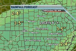
Heavy rain stretching all the way from Texas to Ohio is tracking over the same areas and causing flash flooding. Several counties are under flash flood warnings and the entire viewing area is under a flash flood watch until Friday morning. The axis of heavy rainfall is forecast to slowly shift southeastward tonight and tomorrow. If it's not raining where you are, it will be by tonight. An additional 3-5" of rain is forecast to fall with locally higher amounts exceeding 6". Many roadways across the northern part of the Ozarks are impassible and that trend will only worsen tonight further south. Be prepared to move to higher grounds if you experience flooding. Don't risk your life by attempting to cross a flooded roadway.

Wednesday, October 7, 2009

MAJOR STORM SYSTEM

All the right ingredients are forecast to come together on Thursday for strong to severe storms to develop from Texas to Oklahoma to the Ozarks. The environment is favorable for tornadoes in isolated cells that develop and perhaps within a broken squall line. Damaging wind gusts and hail will also be possible. The greatest threat for severe storms as of today is across northeastern Oklahoma. The timing of the event is during the afternoon and evening hours before weakening across the Ozarks during the overnight hours. The main threats across the Ozarks will be damaging straight line winds and hail to the size of quarters. Strong wind shear will create a marginal risk for an isolated tornado across far southwest Missouri.


The biggest concern from the slow moving frontal system is for heavy rainfall and flooding on Thursday and Thursday night. Overnight, scattered storms will be possible across the far northwestern corner of the Ozarks. Severe storms are not expected during that time frame. Heavy rainfall leading to flash flooding is expected on Thursday into early Friday. Widespread amounts of 3-5", with locally higher amounts are possible. A flash flood watch remains in effect from late tonight through Friday morning. This episode of heavy rainfall will result in significant flooding of small streams, creeks and rivers.
REMEMBER TO NEVER TRY AND DRIVE ACROSS A FLOODED ROADWAY!
FLASH FLOODING KILLS MORE PEOPLE EACH YEAR THAN TORNADOES AND LIGHTNING!!