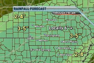


Heavy rain stretching all the way from Texas to Ohio is tracking over the same areas and causing flash flooding. Several counties are under flash flood warnings and the entire viewing area is under a flash flood watch until Friday morning. The axis of heavy rainfall is forecast to slowly shift southeastward tonight and tomorrow. If it's not raining where you are, it will be by tonight. An additional 3-5" of rain is forecast to fall with locally higher amounts exceeding 6". Many roadways across the northern part of the Ozarks are impassible and that trend will only worsen tonight further south. Be prepared to move to higher grounds if you experience flooding. Don't risk your life by attempting to cross a flooded roadway.


No comments:
Post a Comment