MSU Storm Chase Class

Tuesday, March 31, 2009

A Tad Frosty


As wind begin to slacken tonight and clear skies remain, a threat for frost exists for the area in light blue above. High pressure will move overhead which at first will allow for the calm conditions but by Wednesday will have moved east, putting us back in southerly breezes and normal highs in the lower sixties.

Thursday Rain


A storm system is expected to track to our south Thursday and a shield of heavier rain should accompany this storm. A couple of inches of rain are possible especially in north central Arkansas and south central Missouri where thunderstorms will also be mixed in. Even though the storm is passing to the south, it doesn't look like enough cold air will be in place to produce any winter precipitation.


Monday, March 30, 2009

Wind (and storm?)


It has been a windy day across the Ozarks. Winds have gusts over 30 mph commonly today and a wind advisory has been posted.
A cold front will sweep through later tonight. Out ahead of this feature, a few strong thunderstorms may develop and some may produce severe wind gust. Tis activity appears to be more likely to the west and southwest of Springfield during the evening and overnight hours.


Friday, March 27, 2009

Snow Update!

Well, it's a late season snow! The good news is we won't come close to the blizzard conditions experienced in Colorado and Kansas. But the Ozarks will see some accumulating snow on Saturday. Points north and west of a line from Joplin to Osage Beach may see 2" of snow by the time it wraps up late Saturday evening. Springfield will get about an inch. Areas southeast will see a dusting or none.

Travelers should be aware that the K.C. area will see about 4-8" and areas of south central Kansas will pick up 8-14"!!!

Thursday, March 26, 2009

Snow potential on Saturday

WINTER STORM WATCH HAS BEEN EXPANDED EASTWARD AND GOES INTO EFFECT FROM SATURDAY MORNING THROUGH LATE SATURDAY NIGHT.
WINTER STORM WATCH GOES INTO EFFECT ON FRIDAY NIGHT UNTIL SATURDAY EVENING. 4-8" OF SNOW WILL LOCALLY HIGHER AMOUNTS WILL BE POSSIBLE ACROSS THE AREA UNDER THE WATCH.
This computer model indicates heavy snow arriving in W. MO/NW AR on Saturday morning.
The track of the heavy snow band is further east and impacts a good chunk of the western and northwestern portion of the Ozarks on Saturday morning and afternoon than compared to the other computer model down below.


By Saturday evening, snow will gradually be lifting out....


The probability of 4 or more inches of snow is greatest in the area outlined in red between Saturday and Sunday morning. There is at least a 40% chance of 4 or more inches across southwest Missouri and the Osage Plains during that time frame as well.
This computer model shows a slower track and has the heaviest snow band setting up just outside of the viewing area by Saturday evening.
This same model continues to indicate chances for snow into the overnight hours on Saturday with the heaviest falling across the northwestern half of the Ozarks.

Timing, speed of the system, track of the low, and temperatures are all critical as to how much, when and where snow might fall. At this point in time, the models continue to differ as shown above. It appears though, the consensus is that snow will fall especially across western Missouri at some point on Saturday. There is still a lot of uncertainty and we will continue to monitor the situation closely. If you have any questions or thoughts feel free to leave a comment.

Wednesday, March 25, 2009

Heavy Rain Potential

The image is the Hydrological Prediction Center's 1-3 precipitation total ending at 7 pm Saturday. One large batch of rain is due in Thursday evening into early Friday. More is due late Friday and early Saturday. There is still a possibility of some snow mixing in with this over the area on Saturday. There does appear to be a chance for accumulating snow in areas northwest of Springfield. Computer models are differing on this storm, watch the Weather Lab for updates!

Tuesday, March 24, 2009

Next Big Storm


The next big storm will see us between an outbreak of severe weather to the southeast on Friday and a band of accumulating snow late Friday and Saturday. We will see lots of rain Friday and a few storms. On Saturday, there is a possibility that showers will be mixed with or change over to wet snow!

Severe Storm Chances Today!!!


IMAGE AS OF 12:08PM ON TUESDAY, MARCH 24.

Strong to severe storms will impact the Ozarks from west to east this afternoon. Some of the storms may produce winds in excess of 60 mph, quarter size hail and brief spin ups. The other and more dangerous hazards from these storms is heavy rainfall which is leading to flash flooding. Roads are becoming impassable, especially near low water crossings. Don't attempt to cross a road that is flooded. There is a severe thunderstorm watch in effect across parts of the Ozarks along with a wind advisory until 4pm.


SEND STORM REPORTS, PICTURES & VIDEOS TO WEATHERLAB@OZARKSFIRST.COM.

Monday, March 23, 2009

Storm Update

Storms have fired in Kansas and Oklahoma. One cell produced a few tornado reports as it passed south of Wichita earlier. The area in the oval above will form a squall line which will approach areas far to the northwest of Springfield overnight tonight.

Meanwhile, a few isolated storms may fire in southwest Missouri this evening but will stay below severe limits.

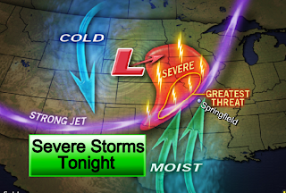
Severe Storms Tonight


The Ozarks will find themselves on the edge of some severe thunderstorms late tonight. Storms will fire over central Oklahoma and Kansas, form a line, and then move northeast, impacting areas to the west and north of Springfield after midnight. All forms of severe weather are possible with these storms including the possibility of tornadoes.

Another update will be posted at 6:35 this evening. Please watch the 5 and 6 o'clock news on KOLR-10 for the latest and make sure to tune into the Weather Lab when the weather turns severe!

WIND ADVISORY

A WIND ADVISORY IS IN EFFECT TODAY

Strong and gusty southerly winds have developed today. Sustained winds of 25-35 mph with gusts to 45 mph can be expected generally along and west of highway 65. Winds this strong can make driving difficult especially for high profile vehicles. Drive with caution!

Saturday, March 21, 2009

SEVERE STORMS POSSIBILITY


A powerful storm system will cause strong to severe storms to develop across Oklahoma, Kansas and Nebraska on Monday afternoon. Those storms will likely continue overnight along a surging cold front across portions of the mid and lower Missouri valleys and perhaps into the Ozarks Plateau. All modes of severe weather are possible on Monday nt-Tuesday morning, however, the primary hazards look to be large hail and damaging winds at this time. Storms will be strongest across western Missouri and Arkansas and will have the tendency to weaken as they track eastward across the Ozarks during the late morning hours and early afternoon hours on Tuesday. Severe weather will still be a possibility though I think the concern will shift towards flash flooding. We could receive 1-2" of rain with locally higher amounts.

FIRE DANGER

Lately we've had some problems with wild fires in Missouri, especially across Laclede county. We are currently running 3" behind our yearly normal rainfall and anytime the humidity drops below 30% and winds are gusty there is an increased threat for fire danger. Fire risk tends to increase during early spring due to several factors shown in the diagram above. If you need to do any burning of debris it's a good idea to do it after we've received a soaking rain and to make sure you keep tabs on the weather to see if the conditions are good or poor for burning. It also doesn't hurt to contact your local fire department and ask if it is safe to burn. If you are a smoker, it's wise to make sure you put the cigarette out completely and to never just toss it outside because it can potentially start a fire on a dry and windy day.

Thursday, March 19, 2009

Spring officially begins on Friday!

An Equinox occurs twice a year, when the tilt of the Earth's axis is inclined neither away from nor towards the Sun, the Sun being vertically above a point on the Equator. Around the Equinox, the night and day are approximately equally long.

Wednesday, March 18, 2009

Severe Late Sunday-Monday

The Ozarks will be on the eastern edge of this thunderstorm area during this time. Jet stream winds and a return northward of some Gulf moisture will help to develop these storms.

Note that this whole pattern will likey shift east on Tuesday with a better chance for storms and rain for the Ozarks. There is a possibility for severe storms for us on this day as well.

Anniversary of the Tri-State Tornado


It is, by a wide margin, the deadliest tornado to strike the United States.

Starting in Reynolds County, Missouri, this tornado was on the ground for over three hours, killed close to 700 people, wiped several towns off the map and reached speeds over 60 mph.

Here are several links:

The Tornado Project

Paducah, KY National Weather Service

Google for more....

Sunday, March 15, 2009

OUR NEXT COLD FRONT

WEDNESDAY EVENING TEMPERATURE/WIND FORECAST
CAN YOU LOCATE THE COLD FRONT?
WEDNESDAY EVENING DEWPOINTS, WHICH SHOWS SOME BUT NOT A TON OF MOISTURE AHEAD OF THE FRONT. TYPICALLY, YOU NEED READINGS IN THE UPPER 50S AND LOWER 60S FOR AN INCREASED CHANCE FOR SEVERE STORMS.


WEDNESDAY NIGHT'S PRECIPITATION FORECAST.
IT DOESN'T APPEAR THAT THE ATMOSPHERE WILL BECOME UNSTABLE ENOUGH FOR SEVERE WEATHER TO OCCUR.

Saturday, March 14, 2009

WARMING TREND....


The warming trend continues.... On the 11th we had a high of 37 degrees, 43 degree on the 12th, 50 degrees on the 13th and 55 degrees today. The image above shows the predicted highs on Tuesday to be well into the 70s!!!

NO BIG WEATHER SYSTEMS FOR A FEW DAYS


Today, the mid-level disturbance is tracking northeast towards Iowa and has enough lift ahead of it to keep it cloudy across the Ozarks on Sunday(Today). The disturbance will exit tonight and skies will clear. Watch out for fog developing, especially in low lying areas. More sunshine is expected tomorrow along with milder temps.

YESTERDAY
This is a water vapor image that shows moisture at mid-levels of the atmosphere. If you go to:
http://www.ral.ucar.edu/weather/satellite/ you can select either a still image or a loop. I think the loop is really cool to look at! The swirl that I circled is a disturbance at mid-levels. That disturbance will keep clouds in the forecast for Sunday and might produce enough lift to cause a shower or sprinkle to develop.

Friday, March 13, 2009

National Weather Service Assesses Super Tuesday Tornado Outbreak


A nice "review of the review" of this can be found here.

This occurred on the same day as the Gassville, AR tornado and of the EF4 that produced a record path length in Arkansas. Our blog list for this day.

Wednesday, March 11, 2009

SNOWFALL FORECAST

There is a winter weather advisory in effect tomorrow across northern Arkansas.


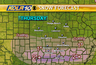
An upper level disturbance will cause moisture to lift northward tomorrow while cold air pushes southward. Initially a bit of sleet may fall across northern Arkansas before changing over to all snow. Amounts will vary dramatically from Arkansas into southern Missouri. It appears a band of heavy snow will set up across northern Arkansas where greater than 2 inches will be possible. But this area has been shifted more to the south and is very narrow.

The models are in better agreement toward reducing overall snow totals today. Dry air and temperatures will be limiting factors.

Snow/Sleet Area


The Weather Lab is watching northern Arkansas and extreme southern Missouri for possible snow accumulation late tonight through early afternoon Thursday.
The latest arctic airmass is supplying enough cold air to this area to make the northern portion of a developing shield of rain capable of changing to sleet or snow.
The factors for determining snow totals are how much rain and/or sleet will be mixed with this precipitation and what will be the intensity.
Look for at least the possibility of a few inches of snow in the northern tier of counties in Arkanas including the cities of Harrison, Mtn. Home, Salem, Jasper and Marshall.
This is forecast to begin as rain and make the changeover sometime overnight tonight.

Tuesday, March 10, 2009

Severe Weather Tuesday 3/10/09


Look for a round of severe weather in the Ozarks on Tuesday.

Storms should fire in the early afternoon and the progress east and south over the area.
Instability looks weak and the winds are not real favorable for tornadoes but an isolated cell could develop one at some point late this afternoon or early this evening.

Tornado Drill for Missouri Today, Tuesday 3/10

The statewide tornado drill is scheduled for 1:30 today. Severe weather concerns appear to have lessened for that time of the day so as of now the drill will take place.

Sirens will go off and a test tornado warning will be transmitted, causing NOAA weather radio to alarm. Remember, this is only a test!

If your weather radio doesn't work or you need help programming it, you can always contact us at the Weather Lab. Or you can come out to JCPenney at the Battlefield Mall from 10 am to 4 pm, Saturday, March 14th.

Tornado Warning

A tornado warning has been issued for northern St. Clair until 1:15 am. This is a bowing segment thunderstorm type will is capable of producing damaging winds along its leading edge and perhaps a brief tornado.

This storm will continue to track into Benton Co. by 1:15 and may again showing a tightening rotation enough for another tornado warning.

Monday, March 9, 2009

Severe Weather Update 3/9 9:30 PM


Severe Weather Update 3/9 7:50 PM


Severe Storms Monday 3/9


Severe probability and tornado probablity for this evening and overnight.
The overall situation features the rapid return of moisture and instability northward through Oklahoma and into southeastern Kansas late this afternoon and early evening. This will flow straight into a very favorable wind shear pattern.
A narrow corridor of higher tornado probability exists on an axis from around Oklahoma City to Bolivar during this period.
I expect storms to initially develop in all long this axis tonight, forming a sort of "daisy chain" effect with the greatest tornadic potential for storms more to the west. These storms will then ride into our viewing area this evening and later tonight.

Sunday, March 8, 2009

SEVERE STORM THREAT ON MONDAY

A warm front lifts northward tomorrow causing showers and storms to develop along and ahead of it across Oklahoma and Kansas. Some of the storms may be severe. The strongest storms appear as though they'll mainly impact Kansas and Oklahoma though a few may hold together and track into western Missouri tomorrow afternoon and evening.

Saturday, March 7, 2009

STORM PREDICTION CENTER OUTLOOK

SLIGHT RISK FOR SEVERE STORMS TNT
GREATEST THREAT FOR DAMAGING STRAIGHT-LINE WINDS

GREATEST THREAT FOR LARGE HAIL


TORNADO THREAT

TRACKING THE STORMS

Discrete cells across Kansas continue to show signs of rotation and have spawned a tornado or two today. These cells are tracking northeastward, however, the entire cluster is gradually sliding east. The greatest threat for large hail, damaging winds and isolated tornadoes tonight will be across eastern Kansas and the northwestern portion of the Ozarks. If you live in a line from Nevada to Warsaw and points northwestward, you are in an area where the potential for severe storms is the greatest. Overall, the threat for tornadoes is low tonight but can't be ruled out.

Thursday, March 5, 2009

Severe Weather This Weekend


Tornado Probability last Saturday 3/7/09

Severe risk today Saturday 3/7/09
Some scattered storms will develop by late afternoon in the Ozarks and out to the west.

The air is expected to be somewhat more stable for showers and storms which develop over the Ozarks late Saturday but storm which fire out west have a better chance of being isolated severe. These storms could move into the western portion of our viewing area by evening.
If clouds break this afternoon, more substantial heating at the ground will lead to more unstable air. This coupled with a strong and favorable wind pattern is why the tronado probablity has gone up for areas west and north of Springfield.

A cool front which was to move through late Saturday night now appears as if it has lost much of its punch Sunday meaning the the day will really be pretty warm and scattered showers and storms may still be around especially to our east and south.

The next front next week looks stronger and severe weather will be possible as it approaches. A pattern similar to this one may set up again Monday.


Tuesday, March 3, 2009

RECORD HIGHS ON FRIDAY??

An upper level ridge continues to track eastward and will bring the warmest air of the winter on Thursday and Friday. Record highs are going to be possible across western Missouri on either Thursday or Friday.


Springfield Records:

March 5 82 degrees 1908

March 6 83 degrees 1974


Joplin Records:

March 5 81 degrees 1961

March 6 82 degrees 1974

Thursday Highs: NO RECORDS
Springfield: 75
Joplin: 78
West Plains: 71
Vichy: 77

NORMAL HIGH: 54

Sunday, March 1, 2009

2-28-09 WINTER STORM ACCUMULATIONS

A strong but fast moving storm system dumped over a half of a foot of snow across central and south central Missouri on Saturday. Springfield received about 1" of snow and the yearly total is now up to 7.3".