MSU Storm Chase Class

Sunday, March 15, 2009

OUR NEXT COLD FRONT

WEDNESDAY EVENING TEMPERATURE/WIND FORECAST
CAN YOU LOCATE THE COLD FRONT?
WEDNESDAY EVENING DEWPOINTS, WHICH SHOWS SOME BUT NOT A TON OF MOISTURE AHEAD OF THE FRONT. TYPICALLY, YOU NEED READINGS IN THE UPPER 50S AND LOWER 60S FOR AN INCREASED CHANCE FOR SEVERE STORMS.


WEDNESDAY NIGHT'S PRECIPITATION FORECAST.
IT DOESN'T APPEAR THAT THE ATMOSPHERE WILL BECOME UNSTABLE ENOUGH FOR SEVERE WEATHER TO OCCUR.

Saturday, March 14, 2009

WARMING TREND....


The warming trend continues.... On the 11th we had a high of 37 degrees, 43 degree on the 12th, 50 degrees on the 13th and 55 degrees today. The image above shows the predicted highs on Tuesday to be well into the 70s!!!

NO BIG WEATHER SYSTEMS FOR A FEW DAYS


Today, the mid-level disturbance is tracking northeast towards Iowa and has enough lift ahead of it to keep it cloudy across the Ozarks on Sunday(Today). The disturbance will exit tonight and skies will clear. Watch out for fog developing, especially in low lying areas. More sunshine is expected tomorrow along with milder temps.

YESTERDAY
This is a water vapor image that shows moisture at mid-levels of the atmosphere. If you go to:
http://www.ral.ucar.edu/weather/satellite/ you can select either a still image or a loop. I think the loop is really cool to look at! The swirl that I circled is a disturbance at mid-levels. That disturbance will keep clouds in the forecast for Sunday and might produce enough lift to cause a shower or sprinkle to develop.

Friday, March 13, 2009

National Weather Service Assesses Super Tuesday Tornado Outbreak


A nice "review of the review" of this can be found here.

This occurred on the same day as the Gassville, AR tornado and of the EF4 that produced a record path length in Arkansas. Our blog list for this day.

Wednesday, March 11, 2009

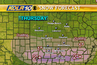
SNOWFALL FORECAST

There is a winter weather advisory in effect tomorrow across northern Arkansas.


An upper level disturbance will cause moisture to lift northward tomorrow while cold air pushes southward. Initially a bit of sleet may fall across northern Arkansas before changing over to all snow. Amounts will vary dramatically from Arkansas into southern Missouri. It appears a band of heavy snow will set up across northern Arkansas where greater than 2 inches will be possible. But this area has been shifted more to the south and is very narrow.

The models are in better agreement toward reducing overall snow totals today. Dry air and temperatures will be limiting factors.

Snow/Sleet Area


The Weather Lab is watching northern Arkansas and extreme southern Missouri for possible snow accumulation late tonight through early afternoon Thursday.
The latest arctic airmass is supplying enough cold air to this area to make the northern portion of a developing shield of rain capable of changing to sleet or snow.
The factors for determining snow totals are how much rain and/or sleet will be mixed with this precipitation and what will be the intensity.
Look for at least the possibility of a few inches of snow in the northern tier of counties in Arkanas including the cities of Harrison, Mtn. Home, Salem, Jasper and Marshall.
This is forecast to begin as rain and make the changeover sometime overnight tonight.

Tuesday, March 10, 2009

Severe Weather Tuesday 3/10/09


Look for a round of severe weather in the Ozarks on Tuesday.

Storms should fire in the early afternoon and the progress east and south over the area.
Instability looks weak and the winds are not real favorable for tornadoes but an isolated cell could develop one at some point late this afternoon or early this evening.