MSU Storm Chase Class

Thursday, April 30, 2009

FLASH FLOODING CONCERNS


Periods of heavy rain is expected through the weekend which could lead to flash flooding. A cold front is forecast to stall out across southern Missouri by tomorrow night. Disturbances will interact with the front and cause rain and storms to develop. Any additional rain falling on saturated soils could easily result in flash flooding and river flooding.

Wednesday, April 29, 2009

SEVERE WEATHER THREAT

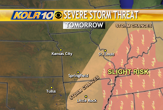
Besides heavy rainfall, there is a threat for severe storms on Friday. Gulf moisture will interact with slow moving or stalling front, causing strong to severe storms to develop late in the day. Forcing will increase at night, as the low level jet kicks in. Large hail and perhaps gusty winds may accompany the storm clusters that evolve across Ozarks. The tornado threat will be greatest across SW Oklahoma and W. Texas during the afternoon hours, due to veering winds in that location. Southwesterly winds are expected locally which is not condusive for rotating thunderstorms.

Tuesday, April 28, 2009

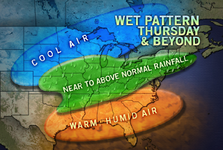
Wet Weather Pattern

There's the potential for 5" of rain to fall over the next 5 days.
Several rounds of heavy rain are expected through early next week. Flooding and flash flooding is going to be a big concern.

Saturday, April 25, 2009

RISK FOR SEVERE STORMS


The Storm Prediction Center has upgraded a portion of the moderate risk area to a high risk. Long-tracked and violent tornadoes are possible across that area today. There is a moderate risk for severe storms from north central Texas to northeast Kansas. There is a slight risk for severe storms across several states including the central and western half of the Ozarks. Storms will be firing across the moderate risk area this afternoon and will need to be watched as they migrate closer to the Ozarks. Computer models continue to indicate the storm activity holding off from pushing into western MO until early Monday morning.
The cold front triggering the storm development makes a move on us on Monday. There is a slight risk for severe storms. Instability will be limited which means storms won't be as intense as they will be today. Some hail and isolated damaging wind gusts will be possible with the strongest storms that develop.

INCHES OF RAIN EXPECTED


1-2" of rain, with areas receiving locally around 3" is possible on Monday. The heaviest rain is expected to fall along and to the southeast of I-44.
The precipitation forecast from this morning until Wednesday morning shows a large area receiving 2" of rain. Southern Missouri and Arkansas could receive 3-4" when all is said and done.

If you live near a low water crossing or river be prepared for flash flooding and eventually river flooding.

Remember to never try to cross a roadway that has water moving across it. It doesn't take much water to move a vehicle! Even if you have a truck, you are powerlessness to the force of water. Flash floods cause more deaths than any other type of weather in the U.S.

Thursday, April 23, 2009

Heavy Rain Potential


Persistent southerly flow off of the Gulf of Mexico has begun which will slowly bring up the humidity levels into this weekend and early next week. This coupled with a slowly-moving upper air pattern with embedded disturbances will lead to several rounds of rain.

In the Ozarks, the first batch will arrive Monday. The map above is a 48 hour rain total forecast which runs from 7 am Sunday to 7 am Tuesday. If this pans out, a large chunk of the Ozarks will see 2-3" totals with more in the extreme western and southwestern portion of Missouri.

Note that another round of rain may occur mid-week with the potential for even more rainfall.

Wednesday, April 22, 2009

SEVERE STORMS OUTLOOK

There is a chance for severe storms on Sunday into Monday across the northwest and southwest portion of the viewing area, including Springfield. A frontal boundary sets up across Missouri and stretches southwestward back into central Oklahoma. Gulf moisture will increase ahead of it, which is one ingredient needed for severe storms.

WARMTH EXPANDS EAST


The last time it reached 80 degrees in Springfield was on March 6. This will be the warmest air we've experienced yet this spring and the longest period with temperatures above 75 degrees.

Tuesday, April 21, 2009

LYRID METEOR SHOWER ON WEDNESDAY MORNING


Sky conditions should be good for viewing the meteor shower late tonight/tomorrow morning. Earth is entering a stream of debris from Comet Thatcher, the source of the annual Lyrid meteor shower. Forecasters expect the shower to peak before dawn on Wednesday. 10-20 meteors per hour are possible. If you don't see any meteors but happen to look to the east just before sunrise you will see the crescent Moon and Venus.

Sunday, April 19, 2009

Flooding Concerns Today...


A flood advisory means river or stream flows are elevated or ponding of water in urban and other areas is occurring or is imminent.

A flood warning means that flooding is immenent or has been reported. Stream rises will be slow and flash flooding is not expected. All interested parties should take necessary precautions immediately though.


Saturday, April 18, 2009

Pattern Change This Week!

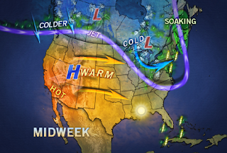
We end the weekend and start off the week with cooler than normal temperatures. While this is going on, a big warm up is taking place to our west. The warmer than normal air is expected to take over beginning on Wednesday. Gulf moisture is also going to be increasing by the end of the week, which will result in warmer overnight lows.

Severe Storms on Saturday


A severe thunderstorm watch in in effect until 12am.

There is a slight risk for severe storms across southwest Missouri and northwest Arkansas. Large hail and damaging winds in excess of 60 mph are the main threats from the severe storms that develop. An isolated tornado cannot be ruled out. Heavy rainfall and frequent cloud to ground lightning can also be expected from these storms.

Storm reports so far today:
-Hail 1-1.5" in diameter. City: Noel County: McDonald

-Hail .88". City: Anderson County: McDonald

-Strong winds blow down several buildings in Anderson at the intersection of 76 and 59.

-Flash flooding is possible in Jasper and Newton county. Radar estimated rainfall of 1 and 1/2 inches has already fallen across those counties.
- 1.31" of rain about 5 miles south of Flemington in northern Polk county.

Wednesday, April 15, 2009

OUR NEXT RAIN MAKER...

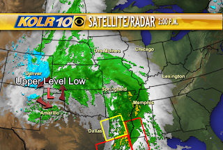
The upper level low near the four corners region will gradually approach the Ozarks from the west as we head into the weekend. It will cause Gulf moisture to increase out ahead of it along with shower and thunderstorm clusters. Rain chances are not expected to go up until Friday night and mainly across southwest Missouri. It may take until Saturday morning for rain chances to spread eastward across the rest of the Ozarks and Arkansas.

Monday, April 13, 2009

Next Batch of Rain/Storms

A large storm in the upper atmosphere will eventually bring rain and thunderstorms back to the Ozarks, perhaps as early as Friday night and then on Saturday through Monday. This storm looks as if it will hang back most of the work week, allowing warmer temperatures to develop out ahead of it. This should translate to at least one seventy-degree day by Thursday, Friday or perhaps both days.

Some Frost Tonight

An opportunity for frost to form tonight exists for folks to the rest of Springfield. This is an area which is expected to having clearing skies first tonight which will allow temperatures to drop to near the level of frost.

Sunday, April 12, 2009

UPPER LEVEL LOW IMPACTS

As of 3pm on Sunday, an upper level low that is currently positioned across the panhandle of Texas is forecast to continue tracking east and at times northeastward across the state of Missouri. We'll experience showers and steady rains from this system and perhaps some thunder tonight.
The upper level system will spark strong to severe storms on Monday afternoon to the east and southeast of the Ozarks.

Thunderstorms remain in the forecast on Monday, mainly to the east of Springfield and Lebanon. These storms again are not expected to be severe.

Saturday, April 11, 2009

STEADY EASTER RAINS....

Rain arrived early today and made an impact on southwest Missouri. The heaviest rain has pretty much exited the Ozarks as of 3pm.

Most areas will receive about .75" of rain with higher amounts exceeding 1" expected to the south.

THE NATIONAL WEATHER SERVICE IN SPRINGFIELD HAS ISSUED A


* FLASH FLOOD WARNING FOR...

BARRY COUNTY IN SOUTHWEST MISSOURI...

MCDONALD COUNTY IN SOUTHWEST MISSOURI...

NEWTON COUNTY IN SOUTHWEST MISSOURI...

Rainfall amounts in SW MO could exceed 2"! Runoff from the excessive rainfall could lead to flash flooding. Don't attempt to cross flooded roadways!

Friday, April 10, 2009

CONFIRMED TORNADO

NWS storm survey confirms that a tornado was on the ground for about 3 minutes last night(8:20-23 pm), about 2 miles to the northwest of Nixa. The damage path was 1.64 miles long and 150 yards wide. The tornado crossed N. Gregg road, W. Tracker road and ended around highway 160. The tornado was rated an E-F0 with winds speeds estimated around 80 mph. Trees and fences are damaged and there is minor damage to more than a dozen homes.

FROST ADVISORY

ADVISORY EXPANDS SOUTHWESTWARD....
Skies clear, winds diminish and a colder air mass settles in tonight causing temperatures to dip into the 30s. A frost advisory goes into effect from 3-8am on Saturday, April 11. A frost advisory means that frost is possible. Sensitive outdoor plants may be harmed if left uncovered.

SOGGY EASTER FORECAST

An upper level system will bring heavy rain to the Ozarks on Easter, mainly during the afternoon and especially the evening hours. 1 to 1.5" of rain is possible at this time. We are not expecting severe weather with this system.

Thursday, April 9, 2009

TORNADO WATCH

WATCH AND WARNING MAP AS OF 10:50PM

Severe storms are exiting the Ozarks.
Tomorrow: send us your storm reports and pictures to weatherlab@ozarksfirst.com and where you are from.
Thanks and have a safe night,
Jill

Wednesday, April 8, 2009

MODERATE RISK OF STORMS TODAY


NEW INFORMATION JUST IN!!!

The storm prediction center has upgraded an area of slight risk to moderate across southwest Missouri, northwest Arkansas, northeast Oklahoma and southeast Kansas. Early showers and perhaps a few elevated thunderstorms will impact the Ozarks, however, those are not expected to be severe. The storms to watch are the ones that develop across Kansas and Oklahoma during the afternoon hours. Those storms will likely be isolated in nature and will have the capability of producing tornadoes (some significant), large hail up to the size of golf balls and damaging wind gusts in excess of 70 mph. They are expected to lift into southwest Missouri and northwest Arkansas towards the evening hours. As they continue to track into southern Missouri and points north and eastward at night they could still produce damaging winds and hail and that's why there is a slight risk for severe storms across the entire viewing area.

Keep checking in for further updates throughout the day! If you have any questions or concerns or input feel free to comment below.

Tuesday, April 7, 2009

FROST ADVISORY TONIGHT


Frost advisory from 2am until 8am Wednesday. If you haven't already, cover your sensitive plants for one more night. Temperatures in the lower to middle 30s may kill your plants if left uncovered.

Sunday, April 5, 2009

BITTERLY COLD START TO THE WEEK

Temperatures will struggle to rise into the 40s on Monday. Cold temperatures combined with gusty winds will make it feel like it's in the teens and 20's. You'll need the winter coat, hopefully for the last time this spring!!!!

FREEZE WARNING


A FREEZE WARNING REMAINS IN EFFECT FROM 7PM UNTIL 9AM TUESDAY.

A hard freeze is expected across the area tonight as temperatures fall into the middle 20s and in wind sheltered areas into the lower 20s. This hard freeze will have a significant impact on sensitive outdoor vegetation and agricultural crops.


Saturday, April 4, 2009

CURRENT WATCHES, WARNINGS & ADVISORIES

RED FLAG WARNING IS IN EFFECT UNTIL 8PM
Strong winds combined with very low humidities will lead to extreme fire weather conditions. Avoid any outdoor burning today!!!
WIND ADVISORY IS IN EFFECT UNTIL 6PM
Sustained winds of 25-30 mph with gusts to 45 mph can be expected in Greene, Webster, Wright, Lawrence, Christian, Barry and Stone counties.
FREEZE WATCH IS IN EFFECT: LATE SUNDAY NIGHT - WEDNESDAY AM

SEVERE STORMS THIS EVENING?

This is the latest regarding the potential for severe weather tonight. The slight risk area has been reduced to include a small portion of northwest Missouri and that's it. Lack of moisture is limiting the development of widespread showers and storms.
Moisture and warmth is slowly creeping northward across Oklahoma and Kansas and will interact with a storm system approaching from the west this afternoon and through the overnight hours. Severe thunderstorms are going to be possible across the western half of the Ozarks. The main threat with any severe storm that develops will be large hail and damaging winds. The risk for tornadoes is mainly across northwest Missouri and NE Kansas.

Friday, April 3, 2009

FREEZING TEMPERATURES

FREEZE WATCH: LATE SUNDAY NT - WEDNESDAY MORNING
Canadian air moves in on Sunday and grows colder with time.
LOW TEMPERATURE FORECAST:
MONDAY MORNING: 27 degrees
TUESDAY MORNING: 19 degrees
WEDNESDAY MORNING: 30 degrees
*Prepare for sensitive outdoor vegetation and agriculture to be impacted by the freezing temps.*
A LOOK BACK AT PAST FREEZES IN APRIL....
2008
April 13: 29 degrees
April 14: 27 degrees
2007
April 5: 29 degrees
April 6: 26 degrees
April 7: 22 degrees (record)
April 8: 20 degrees (record)
April 9: 27 degrees
The freeze in 2007 caused widespread damage to crops and fruit trees across the Midwest.
The freeze taking place next week will not last as long as the one in 2007 though we could easily tie or break the old record high on Tuesday morning.