MSU Storm Chase Class

Monday, March 23, 2009

Storm Update

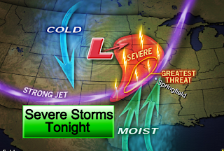
Storms have fired in Kansas and Oklahoma. One cell produced a few tornado reports as it passed south of Wichita earlier. The area in the oval above will form a squall line which will approach areas far to the northwest of Springfield overnight tonight.

Meanwhile, a few isolated storms may fire in southwest Missouri this evening but will stay below severe limits.

Severe Storms Tonight


The Ozarks will find themselves on the edge of some severe thunderstorms late tonight. Storms will fire over central Oklahoma and Kansas, form a line, and then move northeast, impacting areas to the west and north of Springfield after midnight. All forms of severe weather are possible with these storms including the possibility of tornadoes.

Another update will be posted at 6:35 this evening. Please watch the 5 and 6 o'clock news on KOLR-10 for the latest and make sure to tune into the Weather Lab when the weather turns severe!

WIND ADVISORY

A WIND ADVISORY IS IN EFFECT TODAY

Strong and gusty southerly winds have developed today. Sustained winds of 25-35 mph with gusts to 45 mph can be expected generally along and west of highway 65. Winds this strong can make driving difficult especially for high profile vehicles. Drive with caution!