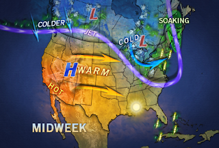
 We end the weekend and start off the week with cooler than normal temperatures. While this is going on, a big warm up is taking place to our west. The warmer than normal air is expected to take over beginning on Wednesday. Gulf moisture is also going to be increasing by the end of the week, which will result in warmer overnight lows.
What Do CoCoRaHS Observers and Kenny Rogers Have in Common?
-
They "drop in to see what condition their condition is in."
OK, I may have lost some of you with that reference, but I couldn't resist.
If you're not sur...
1 year ago


