MSU Storm Chase Class

Wednesday, March 11, 2009

SNOWFALL FORECAST

There is a winter weather advisory in effect tomorrow across northern Arkansas.


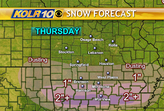
An upper level disturbance will cause moisture to lift northward tomorrow while cold air pushes southward. Initially a bit of sleet may fall across northern Arkansas before changing over to all snow. Amounts will vary dramatically from Arkansas into southern Missouri. It appears a band of heavy snow will set up across northern Arkansas where greater than 2 inches will be possible. But this area has been shifted more to the south and is very narrow.

The models are in better agreement toward reducing overall snow totals today. Dry air and temperatures will be limiting factors.

Snow/Sleet Area


The Weather Lab is watching northern Arkansas and extreme southern Missouri for possible snow accumulation late tonight through early afternoon Thursday.
The latest arctic airmass is supplying enough cold air to this area to make the northern portion of a developing shield of rain capable of changing to sleet or snow.
The factors for determining snow totals are how much rain and/or sleet will be mixed with this precipitation and what will be the intensity.
Look for at least the possibility of a few inches of snow in the northern tier of counties in Arkanas including the cities of Harrison, Mtn. Home, Salem, Jasper and Marshall.
This is forecast to begin as rain and make the changeover sometime overnight tonight.