MSU Storm Chase Class

Thursday, July 30, 2009

Summer Returning Next Week?

The jet stream pattern which has provided us with cooler air and frequent rain shots looks as if it will back off a bit by next week. This week was spent watching this pattern, which had been focusing on the northeast and Great Lake states, gradually deepen and shift westward.

This resulted in a continuous run of cool weather and frequent visits by fronts providing rain and storm chances. The pattern will still be very much in effect through thr weekend with yet another front riding through the area late Saturday.

Now next week, an area of hot weather to our southwest will expand eastward into the plains and begin to heat us up. Nineties will likely return, possibily as early as Tuesday, and might last the week.

The rain pattern will establish itself to our north and east once again as the possibility of ”backdoor cool fronts” (those that back in from the east) returns to the region.


Ted Keller
Senior Meteorologist
KOLR/KSFX-TV
Storm chasing and more at:
Ceaseless Wind

Flood Potential


Today's rain has been persistent and heavy in portions of northern Arkansas and south central Missouri were flash flood warnings are currently in effect.

This rain is slowly exiting to the east and will be gone by overnight. Expect additional 0.50 to 1.00" totals with locally heavier amounts.

Ted Keller
Senior Meteorologist
KOLR/KSFX-TV
Storm chasing and more at:
Ceaseless Wind

Wednesday, July 29, 2009

Rain This Weekend


More wet weather along yet another cool front is expected to impact the area by Saturday afternoon. Expect showers and thunderstorm to develop and move through, moving clear of the area by Sunday morning. Rain totals look to be in the range of .25 to 1.00 inches.

It looks like a warmer and drier pattern of air will finally assert itself being on Monday.

Ted Keller
Senior Meteorologist
KOLR/KSFX-TV
Storm chasing and more at:
Ceaseless Wind

Heavy Rains South of Springfield


A flash flood watch has been issued for areas of north-central Arkansas for tonight and early on Thursday.

An area of heavy rain and thunderstorms is forecast to slide ENE over this region during the period. Rainfall totals in central Arkansas could exceed 4" during this time. The portion of the watch within the viewing area is forecast to receive about 1-2" with locally heavier totals possible.

The rain will give us a break beginning later on Thursday, through Friday and perhaps until early Saturday. By Saturday afternoon, more storms slide in along yet another weak cool front.

Ted Keller
Senior Meteorologist
KOLR/KSFX-TV
Storm chasing and more at:
Ceaseless Wind

Monday, July 27, 2009

Rain Discussion for This Week


A sagging jet stream along with abundant moisture and several cool fronts will lead to extended rainfall chances this week.

The five day rainfall forecast issued by the Hydrological Prediction Center (HPC) is quite inmpressive and concerning for folks living in a swath from northern Texas/southern Oklahoma through portions of Arkansas/Louisiana and on into Mississippi and Alabama. This area is forecast to receive anywhere from 4 to perhaps over 8 inches of rain this week!

The Ozarks sits in the 2-3" range which if spread five days is soggy but not a concern for widespread issues. This situation needs to be watched as the week unfolds.

The first salvo of rain is in connection with a cool front which begins to affect the area on Tuesday and early Wednesday. There appears to be a break in the organized rain on Wednesday. It remains to be seen of another band widespread rain will form later in the week.


Ted Keller
Senior Meteorologist
KOLR/KSFX-TV
Storm chasing and more at:
Ceaseless Wind

Sunday, July 26, 2009

Rain Past & Future


The Ozarks have experienced a normal to slightly above normal pattern of rain this summer, much of this thanks to last week's soaking which laid down the most rain in eastern Kansas and western Missouri. Going back thirty days, only the extreme eastern portion of the region around the Shannon County area is still slightly dry. Turning back three months, the area is still mostly on the dry side except for areas northwest of Springfield.

There are some expectations for rain this week. Recent trends have shifted the bullseye of maximum rainfall to the south of our area over the next five days. Totals in those areas would of course be too excessive; we would be doing well to receive what is on the forecast graphic from the HPC. The current thinking is that the maximum rainfall will be along the front which moved through our region on Saturday an will hang up to our south. Another front will be dropping in Tuesday which will provide us with our mid-week rain. We will avoid getting too much rain if the southern front provides the focus for rain as presently thought.


Ted Keller
Senior Meteorologist
KOLR/KSFX-TV
Storm chasing and more at:
Ceaseless Wind

Saturday, July 25, 2009

TOP 10 COOLEST JULY POSSIBLE

Temperatures so far this July have been below average.
NWS average temperature forecast for this July:
Springfield: 74.7 Joplin: 76.7 Rolla/Vichy: 74.2 West Plains: 74.5
The 10th coolest July on record in Springfield was 74.5 in 2004. It appears that temperatures will need to be cooler than forecast at Springfield to produce a top ten coolest July.
If the current forecast in the other cities is correct then a top ten spot is likely to be reached.
Both Rolla and West Plains are in line for a top five coolest July.
Current Top 5:
Rolla: 74.7 in 1960 West Plains: 74.8 in 2007

Friday, July 24, 2009

Jet Stream Changes Next Week


The weather pattern I mentioned earlier this week still looks plausible for next week.

The jet stream flow aloft which dictates where storms will track and controls large scale temperature patterns will begin to favor wetter weather next week as well as a continuation of below normal temperatures.

What will happen is the overall jet will sag into the central U.S. while individual storms will flow through this and tap abundant moisture residing to the south.


Ted Keller
Senior Meteorologist
KOLR/KSFX-TV
Storm chasing and more at:
Ceaseless Wind

Thursday, July 23, 2009


Another summertime front will work its way through the area, keeping us below normal this weekend. A few scattered storms are likely to pop up especially on Saturday. High temperatures will be in the upper eighties. Thanks to another mid-week front, ninety-degree highs are larger going to avoid the area for the next seven days and proabable a few days beyond!

Ted Keller
Senior Meteorologist
KOLR/KSFX-TV
Storm chasing and more at:
Ceaseless Wind

Wednesday, July 22, 2009

Cool and Wet Next Week?


The jet stream pattern which has provided us with slightly cooler summer and has chilled the northeastern U.S. looks as if it will be shifting more to the central U.S. next week. This means we will continue to see below normal temperatures and perhaps wetter conditions.

There is some evidence in the computer weather models that the shift will cause a front to stall somewhere in the central Great Plains during this period. This usually brings enhanced rainfall to areas along and north of the front. Since summer is a time of deeper moisture (high dew points) to the south of cool fronts, this can mean excessive rain is possible in this zone.


The 6-10 day outlooks issued by the Climate Prediction Center show the cooler temperature departure area in blue and the above average precipitation area in green. The current thinking is to set this front up more to our south be we in the Ozarks should be watching this for possible adjustment.

The whole stalled front episode will likely be followed by another cool shot which will send our lows into the fifties once again with highs only in the seventies.

Ted Keller
Senior Meteorologist
KOLR/KSFX-TV
Storm chasing and more at:
Ceaseless Wind

Tuesday, July 21, 2009

Rainfall Totals 7/21/2009


Rainfall estimated rainfall is shown ending at about 12:30 pm on 7/21/2009. Isolated storms Monday afternoon helped to boost the overall totals in areas around and southeast of Springfield. Eastern Kansas certainly received the heaviest rainfall as they were subjected to both storms and longer lasting rain periods.

The rain is beginning to exit slowly to the east today. Expect totals in areas to the far southeast of Springfield to end up with broad 1-2" totals before the precipitation ends.


Ted Keller
Senior Meteorologist
KOLR/KSFX-TV
Storm chasing and more at:
Ceaseless Wind

Monday, July 20, 2009

Flash Flood Watch Tonight


Flash flood watch posted for a portion of the Ozarks tonight.

Ted Keller
Senior Meteorologist
KOLR/KSFX-TV
Storm chasing and more at:
Ceaseless Wind

Velocity (Doppler) Example


Pictured is a mesocyclone with a tight circulation as revealed by looking at velocity data. Doppler radar "sees" if detected particles carried by the wind has any compontent along the beam itself. Greens are used for particles moving toward the radar while reds are away.

Therefore, a "couplet" as shown here implies strong cyclonic (counterclockwise) circulation. The radar beam comes in from Wichita from the WSW in this image.

FYI, the green triangle is a a software-driven symbol indicating a possible tornado. This is derived by looking at the entire volume of the storm for rotation. The tightest, most persistent and deepest areas of spin will be tagged in this fashion. This software is used extensively "behind the scenes" at KOLR and KSFX.


Ted Keller
Senior Meteorologist
KOLR/KSFX-TV
Storm chasing and more at:
Ceaseless Wind

Unsummer 2004!

The summer of 2004 was a cool one. Summer is officially defined as June, July and August and the temperatures for all three of those months were below normal that year:

  • June 2004 -1.5
  • July 2004 -4.0
  • August 2004 -5.1

Anytime an average temperature is plus/minus 4.0 or more from the normal it is significant.

In addition, we broke four record lows that summer, three of which were in the forties, very chilly!

Records set in 2004:

  • June 23rd, 49
  • July 27th, 52
  • August 13th, 47
  • August 15th, 49

Heavy Rainfall Possible

The Ozarks finds itself in a flow of winds out of the northwest with imbedded weather systems producing areas of showers and storms. The map above is the Monday-Tuesday forecast of rainfall accumulation forecast by the HPC.


Flash flooding could occur locally but the area slated for the heavy rain is experiencing some of the driest weather over the past 30 days according to the Missouri Climate Center.


The rain should slide in this evening and overnight tonight and last through the first half of Tuesday. Temperatures will remain cool for the season through mid-week.

Sunday, July 19, 2009

RECORDS BROKEN OR TIED AND MORE ARE POSSIBLE

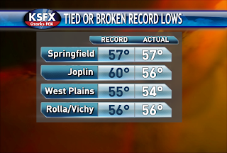
Morning lows were broken or tied!
West Plains and Rolla/Vichy stand another chance of breaking a record low tonight.

HEAVY RAINFALL POTENTIAL ON TUESDAY

The image above shows the predicted amount of rain that could fall between Monday and Tuesday evening. 1-2" of rain is possible across SW Missouri, SE Kansas, NE Oklahoma and NW Arkansas. The least amount of rain is forecast to fall across the eastern half of the Ozarks. If the track of the system shifts further eastward then the heavier amounts will as well.

Saturday, July 18, 2009

RECORD LOWS

Here is a chart of the record lows and the forecast lows for tonight/Sunday morning. Most places stand a good chance of breaking the old record low by a degree or two. Clouds and higher dewpoint readings would be the only factors that could stand in the way of this happening. Clouds act like a blanket and keep heat in at night. The air temperature can never drop below the dewpoint temperature.
The normal high for this time of year is 90 degrees and highs in the lower 80s are likely on Sunday.

EARLY IN THE WEEK

Our next system will be brewing to our west on Monday. The question is which track will the system take??? Models differ "big time" right now. One model shows the rain only grazing the western half of the Ozarks on Tuesday while the other shows a good chance for rain and storms everywhere. For now, I'm leaning towards the drier forecast. Keep checking in for further updates!

Friday, July 17, 2009

Mid-Summer Cool Snap!

A high pressure system from Canada will send our overnight lows this weekend to record-breaking territory. The forecast for Saturday morning is 54 and the record is 53. Sunday morning is being pegged at 53 and the record is presently 57.

Meanwhile, daytime highs will barely get to 80 both weekend days. Dew points will be in the fifties which is very dry and comfortable air for summer. Enjoy!

Wednesday, July 15, 2009

Cool Weekend

A shift in the jet stream will allow cooler air to flow in from Canada this weekend along woth lower humidity. Lows will drop into the fifties both Saturday and Sunday morning while highs will stay in the lower and middle eighties. Record lows may be threaten on these two days especially Sunday morning. Here's a list of the records:

Saturday the 18th: 53 in 1984
Sunday the 19th: 57 in 1984

Weather Watch Hoisted

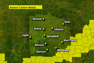
A severe thunderstorm watch has been posted for areas from Springfield east and south for Wednesday afternoon and evening. Downburst damaging winds and isolated large hail may occur in the this region. The left over spinning from a storm cluster last night will provide additional focus for storm in this area.

Tuesday, July 14, 2009

Hottest Ever Recorded in Springfield

On this date, July 14th, 1954, Springfield recorded its hottest temperature of 113 degrees. The next hottest temperature on the books is 108 degrees on July 12, 13 and 18 of the same year.

In fact, July of 1954 has 7 record high temperatures. Not surprisingly, July of 1954 ranks second only to 1934 on the warmest July ranking.

In 1986, (6th hottest) 5 records were established. The last record high broken in July 20th 2006 when we hit 103 degrees.

See other rankings of temperature and precipitation.

Cooler Weather Ahead!


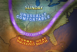
The jet stream will change over the next few days to a more "amplified" (more north-south motion over a greater distance) flow over the U.S later this week. This means cool fronts will actually move through our region. One is due late Wednesday and a reinforcement of cooler air moves through Friday.

This means a return to the below normal temperatures we experienced early in the week of July 6th: lows in the lower sixties (or upper fifties?) and highs in the eighties. Don't forget the lower humidity too!

Sunday, July 12, 2009

SUNDAY EVENING AND OVERNIGHT UPDATE


Wind are flowing from all kinds of different directions across Missouri and surrounding states which clearly shows that we have a couple boundaries around. There is a weak stationary front from Rolla to Kansas City that is currently causing a few light showers to develop along. There is another boundary across southwest Missouri. Notice the winds are coming from the southwest across Oklahoma and from the northeast from Chanute to West Plains. It is where the air converges that you have a boundary, hence lift. As the low level jet kicks in tonight we'll have to watch for further shower and storm development along those boundaries. The most unstable air is located in and around the southernmost boundary. Severe storms can't be ruled out, though we are no longer under a slight risk for them.

Saturday, July 11, 2009

HEAT & PERIODS OF SHOWERS AND STORMS


The northwest flow aloft has been a blessing in ways because it has allowed disturbances to move in which has kept temperatures down. The unsettled pattern is expected to continue through Monday. Where the sun shines the most, temperatures will easily soar into the middle and upper 90s. That kind of heat combined with the humidity in place will make it feel like it's in the lower 100's. We'll remain on the periphery of the heat wave the rest of this weekend! The hottest air is set to move in early in the week before a front moves through on Wednesday and cools us down. Storms that pop up have the potential to become severe, especially tomorrow afternoon across the northeastern half of the Ozarks. Wind gusts up to 60 mph and quarter size hail are the main threats. It appears that the Ozarks will stand a better chance of nocturnal rather than diurnal convection both tonight and tomorrow night due to the low level jet kicking in. The low level jet helps to transport warm and moist air northward and creates an unstable atmosphere at night.

Thursday, July 9, 2009

Weekend and Beyond

The heat and humidity have both been buildly slowly this week with the offical high finally cracking ninety today. While it might get a bit hotter Friday, the temperature climvb is expected to be cut off by the development of clouds, showers and storms starting Friday and lasting through Sunday.

The heat which may require advisories will start Monday and last through Wednesday. Expect some middle nineties on these days and heat index values to common;y rise above 100.

El Nino Pattern Established

The start of El Nino, a pattern of ocean temperatures in the central Pacific Ocean which affects global weather patterns, has been observed and is officially forecast to be with us through winter 2009-2010.

During an El Nino cycle, large areas of the central and eastern equatorial Pacific Ocean experience warmer than normal sea surface temperatures. This produces a flip-flop of normally observed weather on both ends of this region with coastal areas of western South America, normally stable and dry, subjected to more rain and storms while places like Indonesia and Australia, normally wet, seeing a much drier pattern of weather.

Read more about this and other weather information at:

Ceaseless Wind

Tuesday, July 7, 2009

The Heat Will Build Back

The main questions this week are: how hot and whether storms will pop up? The heat will build in slowly this week so that nineties will be common beginning on Thursday. The flow of air aloft is still out of the northwest which is slowing the heat down a bit and may also produce a very isolated shower or storm any day this week.

By Friday, a front drops into northern Missouri, close enough to organize storms perhaps a bit better. Over the weekend, a "backdoor" cool front (from the northeast) will be in Missouri as well. All of this means scattered storms are possible and high temperatures may stay more reasonable through this period.

Sunday, July 5, 2009

THIS WEEK

High pressure builds across northwest Missouri on Monday, causing the winds to flow from the northeast. This flow is a dry one and typically results in cooler than normal readings. Temperatures will once again be below normal with highs in the lower to middle 80s. The unseasonably cool conditions won't last beyond Tuesday due to a ridge of high pressure building eastward with time.
Northwest flow sets up aloft, which is the same flow we experienced during the heat wave. If you recall, we saw brief relief from the heat due to disturbances riding up and over the ridge and across the Ozarks. We could see that same situation set up at times this week. The days in which I'm seeing a disturbance tracking close or across the Ozarks is on Wednesday and Saturday. There is not a big signal for rain this week and is only subtle at this point. Timing and location is still a big question mark. The ridge is forecast to also build eastward with time and cause temperatures to heat up once again. We'll be back in the 90s on Wednesday and staying that way through the weekend.


Saturday, July 4, 2009

4th FORECAST UPDATE

The risk for severe storms no longer exits.

Showers are popping up near Clinton, MO and are sliding ESE. Additional development is possible along and ahead of a cold front that will pass through the Ozarks tonight.

Friday, July 3, 2009

"I LOVE AMERICA"

Temperatures will drop off into the upper 70s by the time fireworks light up the sky tonight. Rain is not expected, a few clouds are possible and it will be muggy and breezy outside. Bring along the bug spray and enjoy the show!
Rain and storms return tomorrow and will mainly impact the Ozarks during the daytime hours. Sunday appears dry and slightly cooler.

INDEPENDENCE DAY


A cold front moves in from the north and causes showers and storms to develop. The storms will be moving in during the afternoon and evening hours before pushing south of the Ozarks by Sunday. Some of the storms could be severe and produce damaging winds, hail, dangerous lightning and heavy rain. Mother Nature's fireworks should come to an end by the overnight hours except across extreme southern Missouri and Arkansas. Make plans to move indoors when the storms arrive and remember to wait 30 minutes after the last clap of thunder before going back outside.

DOG DAYS OF SUMMER


Thursday, July 2, 2009

Holiday Forecast


A front will be moving north through the area on Friday and back south on Saturday. This will mean a chance for storms both times. For Friday, storms near the front should mainly be affecting areas to the north of Springfield. This hopefully will provide a break for the "I Love America" show Friday evening.


Fireworks on the fourth might be a bit trickier. A front will be moving southward on this day and by the time evening rolls around, the main threat for rain and storms should exist from Springfield southward into northern Arkansas.