MSU Storm Chase Class

Tuesday, December 1, 2009

SNOW OR NO SNOW?


The images above are two different computer models showing the precipitation output for tomorrow evening. They clearly differ and mean snow vs no snow for the Ozarks. If the top model is correct then accumulating snow is possible, mainly on grassy surfaces. Most places will see little or no accumulation, but if a heavy band sets up then a couple inches is possible.
Here's a list of the factors limiting snowfall across the Ozarks:
1. The track and speed of the low
2. Dry air in place
3. Timing of maximum lift and cold air
4. Air and ground temperature
The image on top aka NAM model is showing the low tracking much closer to the Ozarks than the image on bottom aka GFS model.
Overall there's a chance for rain changing over to snow. The chance for light accumulation is greatest to the southeast of Springfield. Rain chances will increase after 12pm and a change over is possible during the late afternoon and evening hours from northwest to southeast before the precipitation exits east.

Tuesday, November 17, 2009

Damp and Chilly. Snow?

Well, the chances for our rain showers mixing with snow are about as good as they were. The coldest air now is in extreme southwest Missouri and is not likely to warm much at all this afternoon. The final volley of showers is wrapping around this long-discussed upper level low along an area of converging air.

For snow die-hards, it is still possible in the early evening where the showers wrapping in from the north meet up with the chilliest air. Or at the core of the heavier rain showers. Later tonight and toward morning east of Springfield is another possibility. Elevation will help. NONE of this will amount to more than an inch and only then in grassy areas.

Don't worry, we'll likely have a shot at a real snow this winter. How's that for a forecast! I'm also officially predicting some warmer temperatures this summer...


Ted Keller
Senior Meteorologist
KOLR/KSFX-TV
Storm chasing and more at:
Ceaseless Wind

Friday, November 13, 2009

Rain Chances Late in the Weekend


The models run at a shorter range are now picking up on some pretty good rain late Sunday and Monday. The longer range models have been hinting at this all week too, although they have been way up in the 3" plus range.

There has also been intermittent talk of snow showers early next week. There is a cold core of air aloft in the wake of this rain event which is close to supporting snow in theory. This situation looks interesting but the temperatures at the ground will likely end up too warm to support snow. There is a chance it could mix with lighter showers expected near the core of cold air.

Ted Keller
Senior Meteorologist
KOLR/KSFX-TV
Storm chasing and more at:
Ceaseless Wind

Wednesday, November 11, 2009

Project Vortex 2 Year 1 Summary


This is a summary of what project Vortex 2 accomplished during their first year of operation. It was a very slow severe weather season in 2009, at least within the project’s time and space domain.

The Missouri State University chase class converged with the Vortex 2 armada in Sterling, CO on the evening of Thursday June 4th, the day before they (and Vortex 2!) caught their first tornado near LaGrange, WY, indicated by the red dot on the map.

Many of you on the trip were aware that Matt Gingery parted ways with us in Clinton, MO while on the way home Sunday to go chase in northwest Missouri! On this day, one storm in particular crossed into extreme northwest Missouri. It was well-sampled by Vortex 2 but non-tornadic during the sampling. I believe Matt blogged about this chase on this site. If not, I’m sure he can chime in!

I’ll be curious to see if data collected from that storm produces any insight as to why a tornado didn’t form.

More on Project Vortex 2.

The inserted slide was from a Powerpoint presentation with the following authors listed:

Howie Bluestein (University of Oklahoma)
Don Burgess (CIMMS)
David Dowell (NCAR)
Paul Markowski (Penn State)
Erik Rasmussen (CIMMS)
Yvette Richardson (Penn State)
Lou Wicker (NSSL)
Josh Wurman (CSWR)

Ted Keller
Senior Meteorologist
KOLR/KSFX-TV
Storm chasing and more at:
Ceaseless Wind

Monday, November 9, 2009

Severe Weather Conference

I attended the College of DuPage Severe Weather Symposium held from November 5-7 in Downers Grove, IL.

Some background: the College of DuPage has the longest running, organized storm chase class which just passed its twentieth chase season. Other courses offered at the college provide beginning students of meteorology a “leg up” by providing valuable hands on experience. The program is headed up by professor Paul Sirvakta. Paul is a genuinely nice guy and great facilitator which is why the program is such a success.

Many of you may know that Missouri State University offered a similar (at least logistically) chase class this past June ‘09. It is safe to say that the framework, it not the actual seed for the idea, came from the College of DuPage program.

You can read more about this and other severe weather topics at the website listed below.


Ted Keller
Senior Meteorologist
KOLR/KSFX-TV
Storm chasing and more at:
Ceaseless Wind

Friday, October 30, 2009

Rain, Rain, Rain


Yesterday’s rain total for Springfield was logged at 1.72″ which is a record for that date, 10/29. This has pushed our October rain total to 9.97″ or 6.75″ above a normal October!

The heaviest rain areas occurred east and southeast of Springfield and included numerous 4″ plus totals and even a few over the 5″ mark.

The National Weather Service has a complete rainfall report here.

Ted Keller
Senior Meteorologist
KOLR/KSFX-TV
Storm chasing and more at:
Ceaseless Wind

Tuesday, October 27, 2009

Late Week Storm


The story of the week is the approach of a powerful storm in the upper atmosphere, scheduled to arrive in the Thursday/Friday time frame.

The system is expected to "occlude" which means the most unstable air should stay south of the majority of the Ozarks. This should have the affect of keeping widespread severe thunderstorms either out of our area or possible south of Springfield in extreme southern Missouri or northern Arkansas.

Rainfall seems to be exploding more to our east and southeast as per the HPC rainfall forecast. Computer model forecasts for Springfield specifically are all over, ranging from only around .25" to well over 1.00". It seems as if areas most likely to skew to inches of rain would be areas to the south and southeast of Springfield.

Ted Keller
Senior Meteorologist
KOLR/KSFX-TV
Storm chasing and more at:
Ceaseless Wind

Monday, October 26, 2009

Big Storm Late Week


The system hung up over the Ozarks Monday and Tuesday is wet but rather weak.

A much stronger weather system is taking shape for Thursday and Friday, one which will bring strong, possibly severe, storms to the Ozarks along with more heavy rain.

More on this developing storm on KOLR News at 5, 6 & 10 and Fox News @ Nine!


Ted Keller
Senior Meteorologist
KOLR/KSFX-TV
Storm chasing and more at:
Ceaseless Wind

Coolest Has Ruled!

It's interesting to note that since July, every month has seen its average temperature below normal:

July: -4.3
August: -3.8
September: -2.2
October(through 25th): -7.6


I will talk more about these stats and also "reflect" on the unusual amount of rain and cloud days through this same period tonight at 5, 6 & 10 on KOLR and FOX News @ Nine!


Ted Keller
Senior Meteorologist
KOLR/KSFX-TV
Storm chasing and more at:
Ceaseless Wind

Saturday, October 17, 2009

Frost/Freeze Tonight


The clouds we've been wanting to get rid of will finally break rather quickly tonight allowing temperatures to plummet!

The center of the high where the calmest winds will be will pass over central Missouri tonight and this area is under the greatest risk for a sun-freezing low temperature. The rest of the area will likely experience a pretty good frost.

Ted Keller
Senior Meteorologist
KOLR/KSFX-TV
Storm chasing and more at:
Ceaseless Wind

Winter Outlook


The government (NOAA) has issued a forecast for the winter season. This is an El Nino year which means the waters in the equatorial eastern Pacific are unusually warm.

Every El Nino is slightly different but generally speaking, the southern storm track becomes more active especially in the western and southeastern U.S. Dry and mild air occupies much and the central and northern U.S. The centers of dry/moist warm/cold are away from the Ozarks which means we are somewhat "El Nino Neutral" with no probability of a significant pattern shift.

It should be noted that our multi-month run of below normal temperatures and slightly wet conditions seems poised to continue. Except for a spurt of warmth this week (still mostly below the norm), the forecast for just about the rest of October is a cool one.

It might work out that our winter will see a progression of "dry" cool fronts with cooler but not bitterly cold air following and that every once in a while one of these fronts will hang up along with a slight change in the jet stream and spit out meaningful precipitation; the exact type a bit hard to pin down honestly.

The complete NOAA forecast link.


Ted Keller
Senior Meteorologist
KOLR/KSFX-TV
Storm chasing and more at:
Ceaseless Wind

Monday, October 12, 2009

FALL FOLIAGE


We need cool sunny days followed by cooler nights to have good color. It takes sunny days with temperatures in the 50s, then cooler nights with temperatures in the lower 40s to produce strong color. The temperatures spread between day and night needs to be at least 10 degrees and 15 degrees is better. A frost does not help develop strong color. If leaves freeze hard the chemical process of color change stops and the leaves simply turn brown. Leaves are changing fast but is atleast 2 weeks away from the major peak color across southern Missouri and northern Arkansas.

FALL FOLIAGE LINKS:


Friday, October 9, 2009

FLOODING UPDATE and TOTALS

A FLOOD WARNING is in effect for the following rivers:
JAMES RIVER AT GALENA, BIG PINEY RIVER AT FORT LEONARD WOOD ,SAD RIVER NEAR CAPLINGER MILLS, ELK RIVER, LITTLE OSAGE RIVER, MARMATON RIVER, OSAGE RIVER, SHOAK CREAK, AND SPRING RIVER.
Do not drive through flowing water. Nearly half of all flood fatalities are vehicle related. As little as 6" of water may cause you to loose control of your vehical. Two feet of water will carry most vehicles away.
A FLOOD WARNING remains in effect until 10 am on Saturday.
STORM RAINFALL TOTALS FROM VIEWERS:
- 6" between Strafford and Northview
- 9.75" in Urbana
- 7 to 7.5" east of Marshfield
- 6.5" west of Gainesville
- 4.5" yesterday and 3.5" today in Nixa
- 6.8" west of Nixa
- 7" in Rogersville
- 7" in Stotts City
- 4.88" in Battlefield
- 4.78" in Mtn. Home
- 6.5" in Ozark
- 5.03" in Seymour
- 5.5 to 5.75" in Springfield
- 4" in Barnett
-7.35" total in Battlefield

Thursday, October 8, 2009

FLASH FLOOD WARNINGS & TORNADO WATCH

The tornado watch in Arkansas also includes Ozark, Howell and Oregon counties in SE MO. The watch is in effect until 3am. The severe threat will increase tonight as a line-segment moves across Arkansas. A tornado threat along with hail and damaging winds will be possible with supercells that develop and bowing line-segments. The biggest threat tonight will come from the rain and flash flooding.

SIGNIFICANT FLOODING IS POSSIBLE


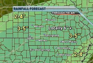
Heavy rain stretching all the way from Texas to Ohio is tracking over the same areas and causing flash flooding. Several counties are under flash flood warnings and the entire viewing area is under a flash flood watch until Friday morning. The axis of heavy rainfall is forecast to slowly shift southeastward tonight and tomorrow. If it's not raining where you are, it will be by tonight. An additional 3-5" of rain is forecast to fall with locally higher amounts exceeding 6". Many roadways across the northern part of the Ozarks are impassible and that trend will only worsen tonight further south. Be prepared to move to higher grounds if you experience flooding. Don't risk your life by attempting to cross a flooded roadway.

Wednesday, October 7, 2009

MAJOR STORM SYSTEM

All the right ingredients are forecast to come together on Thursday for strong to severe storms to develop from Texas to Oklahoma to the Ozarks. The environment is favorable for tornadoes in isolated cells that develop and perhaps within a broken squall line. Damaging wind gusts and hail will also be possible. The greatest threat for severe storms as of today is across northeastern Oklahoma. The timing of the event is during the afternoon and evening hours before weakening across the Ozarks during the overnight hours. The main threats across the Ozarks will be damaging straight line winds and hail to the size of quarters. Strong wind shear will create a marginal risk for an isolated tornado across far southwest Missouri.


The biggest concern from the slow moving frontal system is for heavy rainfall and flooding on Thursday and Thursday night. Overnight, scattered storms will be possible across the far northwestern corner of the Ozarks. Severe storms are not expected during that time frame. Heavy rainfall leading to flash flooding is expected on Thursday into early Friday. Widespread amounts of 3-5", with locally higher amounts are possible. A flash flood watch remains in effect from late tonight through Friday morning. This episode of heavy rainfall will result in significant flooding of small streams, creeks and rivers.
REMEMBER TO NEVER TRY AND DRIVE ACROSS A FLOODED ROADWAY!
FLASH FLOODING KILLS MORE PEOPLE EACH YEAR THAN TORNADOES AND LIGHTNING!!

Sunday, September 27, 2009

COLDEST AIR OF THE SEASON

Low pressure tracking across the Great Lakes region sends a cold front through tonight. It will be windy and warm ahead of the front and breezy and much colder behind the front. Highs will struggle early in the week to rise to 70 degrees and overnight lows in the 40s will be common. Record lows are not expected though temperatures will be running around 10 degrees below normal.
By the middle of the week, the cold air lifts out and seasonal air moves in ahead of the next approaching storm system. The good thing about this week is that we'll see dry weather lasting until Thursday.


A POTENT SYSTEM LATE IN THE WEEK

Computer models continue to indicate a strong storm system swinging southward across the Midwest on Thursday and causing strong to severe storms to develop. The timing has fluctuated over the past few days though the overall consensus has been Thursday evening all along. We'll continue to monitor the development of this system and pass along any new information as we receive it. The air mass following this system is nearly as cold as the one moving in early in the week.

Saturday, September 26, 2009

SUMMER-LIKE SUNDAY


Temperatures rise above normal on Sunday, with highs in the lower to middle 80s. Normal highs are in the upper 70s this time of year. Southwest winds increase ahead of an approaching cold front tomorrow, which will advect the summer-like air mass northward. The cold front is set to pass through at night and bring fall readings to the Ozarks early in the week.

A BIG COOL DOWN IS COMING...

A dry cold front is forecast to pass through on Sunday night and bring the coldest air of the season so far. Highs will struggle to rise into the 70s on Monday. Lows in the lower 40s are a good possibility by Tuesday morning, which is the coldest air we've experienced since the middle of May. The below normal air mass will only linger for a couple of days before we warm back up again.

Monday, September 21, 2009

Heavy Rain Tonight


A slow moving front will continue to drop in some cases inches of rain on the Ozarks through tonight. The areas which will receive the most are portions of Greene, Lawrence, Barry, Jasper, Newton and McDonald Counties in Missouri and Benton and Washington Counties in northwest Arkansas where over 3" could fall locally.

Ted Keller
Senior Meteorologist
KOLR/KSFX-TV
Storm chasing and more at:
Ceaseless Wind

Sunday, September 20, 2009

STRONG STORM SYSTEM EARLY IN THE WEEK

The jetstream digging southward across the Midwest sends a strong cold front our way. The right atmospheric conditions will come together causing severe storms to develop late on Monday. The primary threats are damaging winds, large hail and flooding rains. The western Ozarks stand the greatest chance of experiencing severe weather. Areas to the east of highway 65 will mainly deal with weaking storms and heavy rainfall late on Monday night and into Tuesday morning.
Here is a general rainfall forecast for Monday night through Tuesday night. Locally higher amounts will definitely be possible. The heaviest rain is forecast to fall across an area that has already seens several inches of rain. Flash flooding is a definite concern and a watch may be issued later in time from the National Weather Service.

Saturday, September 19, 2009

SATURDAY'S BLOB OF RAIN

This is the radar image as of 12:35 pm on Saturday. A blob of rain with isolated storms is tracking northwestward at 30 mph. The heaviest rain is concentrated southeast of I-44. A flash flood warning is in effect until 5pm across southern Ozark, northern Marion and northern Baxter county. Radar estimates are greater than 2" across MO/AR border, which has fallen since 8 am. Be careful when driving today across the warned area because runoff from the heavy rainfall will cause flooding of small streams, creeks, county roads as well as farmland.

STRONG FRONT ARRIVES ON MONDAY-TUESDAY

A strong cold front approaches the Ozarks on Monday. The image above is the frontal position forecast for Monday morning.
There is a slight risk for severe storms on Monday afternoon and evening across western Missouri. The main risks are damaging winds and hail.
The front is expected to produce heavy rainfall which could lead to flash flooding. The image above shows the amount of rain forecast to fall from now until Tuesday morning. Heavy rain along the front will start impacting our western counties on Monday afternoon and evening and then slowly spread eastward with time. H.P.C. is forecasting 1-2" of rain with locally higher amounts.

Friday, September 18, 2009

Cooler Air on the Way.


The cool front responsible for the storms and rain Monday will move through. Another "cut-off" low in the upper atmosphere is expected to form midweek. This will keep us cool and fairly cloudy post-front. There is a chance for forty-degree lows with this latest shot of cool air.


Ted Keller
Senior Meteorologist
KOLR/KSFX-TV
Storm chasing and more at:
Ceaseless Wind

Severe Storms Monday?


There is a possibility of strong to severe storms on Monday through the central U.S. including the Ozarks.

A cool front is the culprit this time. The front is expected to pass through the Ozarks late Monday. Rainfall amounts could also exceed one inch in many areas late Monday and early Tuesday with this system.


Ted Keller
Senior Meteorologist
KOLR/KSFX-TV
Storm chasing and more at:
Ceaseless Wind

Tuesday, September 15, 2009

Cool Summer for Much of the U.S.


The Ozarks were not alone in having a cool summer. The states in blue all recorded below normal conditions and the numbers indicate the ranking of the state on its overall coolest summer list. Missouri ended up 12th and Arkansas was 23rd.

A persistent trough of low pressure aloft not only kept a constant supply of cool air flowing south from Canada but also kept clouds in the picture through much of the Great Lakes and New England.

We had ranked cool months in July and August in the Ozarks. A heat wave in late June and a brief burst of hot temperatures in early August are the only signs of summer we had in the region.

Complete NOAA report

Ted Keller
Senior Meteorologist
KOLR/KSFX-TV
Storm chasing and more at:
Ceaseless Wind

Low Pressure Backing Up


A weak and isolated low which was previously thought to be moving eastward by later in the week is now forecast to stall a bit more and probably track westward, passing south of the Ozarks, between now and Saturday.

The upshot of this is to keep rain chances going as long as this feature is close by. The 1-3 day rainfall forecast through Friday from the HPC is included, showing areas of western Arkansas forecast to pick up in excess of 4" as a result of this feature.

In the Ozarks, the rain totals ramp up quickly moving southward. A few inches of rain are conceivable in portions of Arkansas.

Bands of showers rotating around this feature will be capabile of producing locally heavy downpours in isolated sections of Missouri too.

It appears as if a weekend cool front will finally "kick" the rain system out of here at that time.


Ted Keller
Senior Meteorologist
KOLR/KSFX-TV
Storm chasing and more at:
Ceaseless Wind

Tuesday, September 8, 2009

Wichita Flooding Rains


A cluster of rain and storms dumped on Wichita early this morning and afternoon. Rainfall totals range from about 2″ to as much as 6″ in the northeastern portion of the city.

The included image is radar-estimated rainfall from the radar site at the airport in Wichita (the data “hole” in southwestern Wichita) which estimates as much as 5-6″ of rain fell in the northeastern part of the city shown in red. Ground measurements verify the radar estimate, a few storm reports:

1034 AM HEAVY RAIN 3 ENE DOWNTOWN WICHITA 37.70N 97.29W
09/08/2009 M4.41 INCH SEDGWICK KS MESONET

STORM TOTAL MEASURED SINCE MIDNIGHT…RAIN STILL
FALLING…REPORT COURTESY KSN WEATHERLAB SITE AT WICHITA
STATE UNIVERSITY

0820 AM HEAVY RAIN BEL AIRE 37.76N 97.27W
09/08/2009 M6.00 INCH SEDGWICK KS BROADCAST MEDIA

FROM THE START OF EVENT THROUGH 820 AM. RELAYED THROUGH
KWCH WEATHER.

0933 AM HEAVY RAIN ANDOVER 37.69N 97.14W
09/08/2009 M4.13 INCH BUTLER KS MESONET

RAIN STILL FALLING…REPORT COURTESY OF KSN WEATHERLAB
SITE AT ANDOVER MIDDLE SCHOOL


Ted Keller
Senior Meteorologist
KOLR/KSFX-TV
Storm chasing and more at:
Ceaseless Wind

Flash Flood Watch


A cluster of rain and some storms with locally heavy rain will visit portions of western Missouri this evening and tonight. Several inches of rain could fall locally along the highway 71 corridor tonight.


Ted Keller
Senior Meteorologist
KOLR/KSFX-TV
Storm chasing and more at:
Ceaseless Wind

Saturday, September 5, 2009

Dense fog develops tonight

Dense fog is expected to develop tonight where the sky clears. The greatest chance for clearing will be along and to the west of highways 65. Fog will begin forming anytime after 10 pm and become thick by morning. If you are doing any late night or early morning traveling, be prepared to slow down and turn off your brights due to low visibility. Fog forms when the air temperature cools and equals the dew point temperature.

HOLIDAY WEEKEND & LABOR DAY FORECAST

An upper level low tracking across central Missouri this afternoon will continue to drift northeastward with time. As it departs, we'll see a spread in weather conditions across the Ozarks on Sunday afternoon. It will be drier and sunnier across western Missouri and Arkansas than compared to the eastern half. Just like this afternoon, showers and storms will pop up on Sunday afternoon but mainly to the east of I-44. Severe weather is not expected, through locally heavy rain is possible with the strongest of storms.
On Labor day the low will be further away than it will be on Sunday, which means less of a chance for showers and storms during the afternoon and evening hours. Slight chances remain possible from Rolla to West Plains to Mtn. Home and points eastward, otherwise it should be dry to enjoy the day off with friends and family. Temperatures will approach seasonal norms, with highs in the lower to middle 80s.


Tuesday, September 1, 2009

Tropical Storm Erika Forms


Tropical Storm Erika looks good on the visible satellite image with a core of organized thunderstorms and good “exhaust” on at the top of the storm. But like “Ana” and “Danny”, Erika has the thunderstorm area displaced to the east of a area of circulation. There is some shear affecting its development at present but plenty of warm water so the storm should strengthen a tad over the next few days.


Ted Keller
Senior Meteorologist
KOLR/KSFX-TV
Storm chasing and more at:
Ceaseless Wind

August 2009 Review

August started on a Saturday with a rain along front which cleared by later in the day. This was followed by a great Sunday. But heat and humidity swelled into the area on Monday the 3rd with dew points and temperatures jumping about 16-18 in a day!

We returned to the pattern of stalled fronts to the north and east firing clusters of storms affecting portions of the Ozarks. A front did manage to keep temperatures in check around the 5th/6th. The heat returned again on the weekend with middle 90's but with a great breeze!

Another front provided rain and cooler temperatures on Monday 10th. Heavy rains fell on this day including a record 2.58" at the SGF NWS. Widespread 2-3" totals occurred in portions Greene, Polk and St. Clair Counties with isolated 4" totals. A very quiet period followed for the rest of the week and into the weekend of the 15/16th. It was a great viewing for the Perseid Meteor shower! Lots of attention on what tropical disburbances in the eastern Atlantic will do including incipent "Bill" and a forgotten "Claudette". The weekend of the 15/16th contained a fair amount of afternoon cloudiness and some rain showers especially west and north of Springfield.

Another front visited on Monday the 17th with some heavy rain totals. But the main front of this week arrived early Thursday. Out ahead of it on Wednesday evening, a tornado watch was posted; a rarity for August. A bowing segment in southeasternKansass turned into a large squall line which blew through the Ozarks. Tornado warnings were hoisted for portions of Dade, Laclede, Newton, McDonald and Barry counties. An EF1 tornado occurred north of Roby in Texas County. Numerous reports of 50-60 mph winds and some light damage. An active storm traveled from Newton and McDonald and into Barry around the midnight hour with several reports of wall clouds and funnels.

A period of much below normal weather set into the area again the following the storms including a fantastic weekend the 22/23 with cool and dry air dominating. In fact, the rest of the month featured below normal temperatures.

The record for Springfield indicates only six ninety-degree high temperatures for August compared to eight days where the high was below eighty. The low dipped into the fifties or lower a total of seven times. The coolest air culmenated with one final high pressure system which produced a tied record low of 48 on the morning of the 31st.

Not counting duplicate averages, this August ranks right around the 10th coolest on record!


Ted Keller
Senior Meteorologist
KOLR/KSFX-TV
Storm chasing and more at:
Ceaseless Wind

Sunday, August 30, 2009

Approaching or breaking record lows tonight

Canadian high pressure sends the coolest air of the summer our way tonight and early tomorrow morning. It will be cold enough for an early frost across parts of the Great Lakes region. We will not get that cold, but cold enough to break a few records.
Enough moisture may be present that Springfield just misses getting down to record cold levels tonight. It will be a close call for records to be reached in Rolla and West Plains. Joplin stands the best chance of beating the old record low of 55 degrees. Record or not, it's going to be cold tonight and you definitely won't need air conditioning on! Open up your windows and save a little money. :)


Late week clouds & shower chances

A disturbance that's currently located across the Pacific northwest will slip southward and remain stagnant across the central Plains from Wednesday through Saturday. The Ozarks will experience a split in weather conditions from west to east. The best chance for rain and cloud cover will be from highway 65 and points westward and the driest and sunniest conditions will be across the eastern Ozarks. Temperatures are forecast to remain below normal through next weekend.


Saturday, August 29, 2009

TIME TO TURN ON THE HEATER?

Canadian high pressure is building southward and will make it feel like fall over the next few days. Most places will experience lows in the 50s on Sunday morning. The further north/northeast you live, the cooler it will be.
The coldest air since June 5th, arrives on Monday morning. Many locations will likely break old record lows. You'll definitely want to turn off the air conditioner and perhaps turn on the heat. Sounds crazy, huh?
AUGUST 31st RECORD LOWS
Springfield: 48 1967
Joplin: 55 1987
West Plains: 50 1988
Rolla: 48 1967