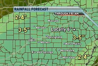
 The tornado watch in Arkansas also includes Ozark, Howell and Oregon counties in SE MO. The watch is in effect until 3am. The severe threat will increase tonight as a line-segment moves across Arkansas. A tornado threat along with hail and damaging winds will be possible with supercells that develop and bowing line-segments. The biggest threat tonight will come from the rain and flash flooding.
What Do CoCoRaHS Observers and Kenny Rogers Have in Common?
-
They "drop in to see what condition their condition is in."
OK, I may have lost some of you with that reference, but I couldn't resist.
If you're not sur...
1 year ago


