Isolated showers and storms will continue to impact the Ozarks through the afternoon hours. Occasional cloud to ground lightning is expected with the activity. This convection will have an impact on temperatures today and it will not be quite as warm as expected. The warmest locations will be across southern Missouri and northern Arkansas. Thunderstorms will develop later today across central and eastern Kansas and track east and northeastward. Northwestern counties in the Ozarks may be impacted by this activity after sunset. Wind gusts to 60 mph and hail up to the size of quarters will be possible.

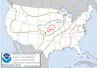
A front pushes into the Ozarks tomorrow and there's a slight risk for severe storms.

The front stalls out either across or near the Ozarks and will provide a focal point for showers and storms to develop along. A few of the storms may be severe on Tuesday.


 Isolated showers and storms will continue to impact the Ozarks through the afternoon hours. Occasional cloud to ground lightning is expected with the activity. This convection will have an impact on temperatures today and it will not be quite as warm as expected. The warmest locations will be across southern Missouri and northern Arkansas. Thunderstorms will develop later today across central and eastern Kansas and track east and northeastward. Northwestern counties in the Ozarks may be impacted by this activity after sunset. Wind gusts to 60 mph and hail up to the size of quarters will be possible.
 A front pushes into the Ozarks tomorrow and there's a slight risk for severe storms.
 The front stalls out either across or near the Ozarks and will provide a focal point for showers and storms to develop along. A few of the storms may be severe on Tuesday.

