MSU Storm Chase Class

Saturday, June 13, 2009

Active Weather Pattern Returns!


Active weather takes over on Sunday and lasts into Tuesday. The tricky part of the forecast is knowing the evolution of storm complexes on a daily basis. As of Saturday night, storms are forecast to organize into a couple of complexes across the Plains. It appears as if one or two of these will impact the Ozarks over the next 24 hours. Disturbances tracking in combined with a surface front meandering around = several chances for storms. Some of the storms could be severe especially if the atmosphere can become unstable enough.

Wednesday, June 10, 2009

A risk of severe storms and flooding exist today in the Ozarks. The severe part seems a little less volitile tha yesterday's activity but the threat of large hail and damaging winds does exists along with a possible tornado near a front from eastern Kansas to central Missouri.

Perhaps a larger threat is the flash flood possibilities. Many areas received several inches of rain yesterday and additional rain in those areas or in new areas is cause for concern today and especially later tonight.

Tuesday, June 9, 2009

Severe Storm Threat Today

Watch out today, a 10% plus threat for tornadoes exists from Springfield westward. A stalled front is returning north as a warm front today. This boundary will be the focus for the most severe storms later this afternoon as they develop over Kansas and move eastward during the late afternoon and evening.


Saturday, June 6, 2009

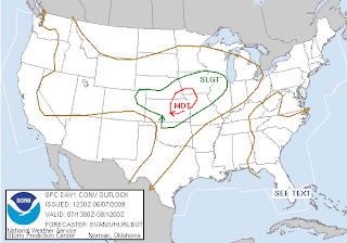
Severe Storm Outlook Through Tuesday

Isolated showers and storms will continue to impact the Ozarks through the afternoon hours. Occasional cloud to ground lightning is expected with the activity. This convection will have an impact on temperatures today and it will not be quite as warm as expected. The warmest locations will be across southern Missouri and northern Arkansas. Thunderstorms will develop later today across central and eastern Kansas and track east and northeastward. Northwestern counties in the Ozarks may be impacted by this activity after sunset. Wind gusts to 60 mph and hail up to the size of quarters will be possible.
A front pushes into the Ozarks tomorrow and there's a slight risk for severe storms.
The front stalls out either across or near the Ozarks and will provide a focal point for showers and storms to develop along. A few of the storms may be severe on Tuesday.

Hottest day over the next seven is SUNDAY

Heat and humidity surges northward ahead of our next approaching frontal boundary. Highs in the upper 80s will be common across the Ozarks, especially the areas that see the most sunshine. The only thing that may hold back temperatures is a bit is cloud cover from a complex of storms to our north.

Wednesday, June 3, 2009

DRIER WEATHER ON THURSDAY

High pressure brings cooler and drier weather to the Ozarks on Thursday. Dewpoints in the lower 50s and upper 40s take over for a day, which will make it feel comfortable outside. Northeasterly winds will also prevent temperatures from warming above the lower to middle 70s. Overall, it will be cool to start and pleasant during the afternoon hours. Let the refreshing air in, because it's going to be heating up again over the weekend!

A LOOK AHEAD AT THE WEEKEND

We warm up ahead of the next approaching storm system. Temperatures and dewpoints will both be increasing over the weekend which will result in afternoon instability. Isolated showers and storms can't be ruled out, however, a warm lid aloft should prevent widespread development. Most places should stay dry and heat up into the middle and upper 80s.