MSU Storm Chase Class

Monday, June 15, 2009

Severe Weather Discussion 1

Radar image at 12:36. Cells have been severe-warned with hail up to 1 1/4" reported. Any storms which follow a boundary such as the warm front or any outflow from morning storms will have to be watched for tornado potential.

Severe Thunderstorm Watch just posted for all of the Missouri portion of the KOLR/KSFX viewing area.

Severe weather update

12:30 PM POSITION OF WARM FRONT ACROSS THE OZARKS

RADAR IMAGE AS OF 12:10PM
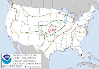
TODAY'S SEVERE WEATHER OUTLOOK
TUESDAY'S SEVERE WEATHER OUTLOOK

DISCUSSION

Severe storms are developing along a warm front and are capable of producing quarter size hail. These storms are drifting eastward at about 15-25 mph. The storms will also be capable of producing damaging winds in excess of 60 mph and isolated tornadoes today. A watch will likely be issued any moment now. Severe storms are possible along the warm front today with additional storms developing towards the evening hours to our west and moving eastward during the overnight hours. The slight risk for severe storms on Tuesday has to do with this activity that will still be impacting the Ozarks during the early morning hours. Check back in for further updates as new information becomes available.

Sunday, June 14, 2009

3 Day Storm Risk

SUNDAY OUTLOOK-DISCUSSION BELOW
MONDAY OUTLOOK-DISCUSSION BELOW

SEVERE STORM OUTLOOK FOR SUNDAY
There is a slight risk for severe storms today if enough heating and lift can occur. Boundaries left behind from morning storms may provide a focal point for afternoon and evening storm development. Early morning convection, however, did stabilize the atmosphere somewhat, which may result in a fairly dry day for us. If a severe storm were to develop it could produce winds in excess of 60 mph and quarter size hail. This evening we'll be watching showers and storms developing across northern Oklahoma and Kansas that might track into the Ozarks during the overnight hours. Some of the storms could be severe and produce very heavy rainfall.

SEVERE STORM OUTLOOK FOR MONDAY
A warm front moves in and transports warm and moist air northward. We could experience two rounds of showers and storms. One in the morning and one in the afternoon. The storms that develop during the afternoon hours along frontal boundary will have to be monitored closely. If enough clearing can occur behind the first round during the afternoon hours, then the chance for severe storms increases. All modes of severe weather will be possible with any severe storm that develops on Monday afternoon. The slight risk might be upgraded to a moderate risk.
SEVERE STORM OUTLOOK FOR TUESDAY
The last round of storms tracks in on Monday night and lingers into Tuesday morning. Same risks on Sunday, apply to this day. The greatest chance for early morning severe storms will be across the northern and northeastern half of the viewing area. The majority of the Ozarks may escape a rain filled day. The weather pattern on Wednesday should switch to a dry one because a trough is forecast to dig across the west which will amplify the ridge across the Midwest. What that means is that the storm track will shift northward and we head up under the ridge! Late in the week we'll be watching a front closely that may put an end to our 2 day stretch of dry weather.

Saturday, June 13, 2009

Active Weather Pattern Returns!


Active weather takes over on Sunday and lasts into Tuesday. The tricky part of the forecast is knowing the evolution of storm complexes on a daily basis. As of Saturday night, storms are forecast to organize into a couple of complexes across the Plains. It appears as if one or two of these will impact the Ozarks over the next 24 hours. Disturbances tracking in combined with a surface front meandering around = several chances for storms. Some of the storms could be severe especially if the atmosphere can become unstable enough.

Wednesday, June 10, 2009

A risk of severe storms and flooding exist today in the Ozarks. The severe part seems a little less volitile tha yesterday's activity but the threat of large hail and damaging winds does exists along with a possible tornado near a front from eastern Kansas to central Missouri.

Perhaps a larger threat is the flash flood possibilities. Many areas received several inches of rain yesterday and additional rain in those areas or in new areas is cause for concern today and especially later tonight.

Tuesday, June 9, 2009

Severe Storm Threat Today

Watch out today, a 10% plus threat for tornadoes exists from Springfield westward. A stalled front is returning north as a warm front today. This boundary will be the focus for the most severe storms later this afternoon as they develop over Kansas and move eastward during the late afternoon and evening.


Saturday, June 6, 2009

Severe Storm Outlook Through Tuesday

Isolated showers and storms will continue to impact the Ozarks through the afternoon hours. Occasional cloud to ground lightning is expected with the activity. This convection will have an impact on temperatures today and it will not be quite as warm as expected. The warmest locations will be across southern Missouri and northern Arkansas. Thunderstorms will develop later today across central and eastern Kansas and track east and northeastward. Northwestern counties in the Ozarks may be impacted by this activity after sunset. Wind gusts to 60 mph and hail up to the size of quarters will be possible.
A front pushes into the Ozarks tomorrow and there's a slight risk for severe storms.
The front stalls out either across or near the Ozarks and will provide a focal point for showers and storms to develop along. A few of the storms may be severe on Tuesday.