MSU Storm Chase Class

Thursday, July 9, 2009

El Nino Pattern Established

The start of El Nino, a pattern of ocean temperatures in the central Pacific Ocean which affects global weather patterns, has been observed and is officially forecast to be with us through winter 2009-2010.

During an El Nino cycle, large areas of the central and eastern equatorial Pacific Ocean experience warmer than normal sea surface temperatures. This produces a flip-flop of normally observed weather on both ends of this region with coastal areas of western South America, normally stable and dry, subjected to more rain and storms while places like Indonesia and Australia, normally wet, seeing a much drier pattern of weather.

Read more about this and other weather information at:

Ceaseless Wind

Tuesday, July 7, 2009

The Heat Will Build Back

The main questions this week are: how hot and whether storms will pop up? The heat will build in slowly this week so that nineties will be common beginning on Thursday. The flow of air aloft is still out of the northwest which is slowing the heat down a bit and may also produce a very isolated shower or storm any day this week.

By Friday, a front drops into northern Missouri, close enough to organize storms perhaps a bit better. Over the weekend, a "backdoor" cool front (from the northeast) will be in Missouri as well. All of this means scattered storms are possible and high temperatures may stay more reasonable through this period.

Sunday, July 5, 2009

THIS WEEK

High pressure builds across northwest Missouri on Monday, causing the winds to flow from the northeast. This flow is a dry one and typically results in cooler than normal readings. Temperatures will once again be below normal with highs in the lower to middle 80s. The unseasonably cool conditions won't last beyond Tuesday due to a ridge of high pressure building eastward with time.
Northwest flow sets up aloft, which is the same flow we experienced during the heat wave. If you recall, we saw brief relief from the heat due to disturbances riding up and over the ridge and across the Ozarks. We could see that same situation set up at times this week. The days in which I'm seeing a disturbance tracking close or across the Ozarks is on Wednesday and Saturday. There is not a big signal for rain this week and is only subtle at this point. Timing and location is still a big question mark. The ridge is forecast to also build eastward with time and cause temperatures to heat up once again. We'll be back in the 90s on Wednesday and staying that way through the weekend.


Saturday, July 4, 2009

4th FORECAST UPDATE

The risk for severe storms no longer exits.

Showers are popping up near Clinton, MO and are sliding ESE. Additional development is possible along and ahead of a cold front that will pass through the Ozarks tonight.

Friday, July 3, 2009

"I LOVE AMERICA"

Temperatures will drop off into the upper 70s by the time fireworks light up the sky tonight. Rain is not expected, a few clouds are possible and it will be muggy and breezy outside. Bring along the bug spray and enjoy the show!
Rain and storms return tomorrow and will mainly impact the Ozarks during the daytime hours. Sunday appears dry and slightly cooler.

INDEPENDENCE DAY


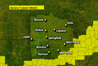
A cold front moves in from the north and causes showers and storms to develop. The storms will be moving in during the afternoon and evening hours before pushing south of the Ozarks by Sunday. Some of the storms could be severe and produce damaging winds, hail, dangerous lightning and heavy rain. Mother Nature's fireworks should come to an end by the overnight hours except across extreme southern Missouri and Arkansas. Make plans to move indoors when the storms arrive and remember to wait 30 minutes after the last clap of thunder before going back outside.

DOG DAYS OF SUMMER