MSU Storm Chase Class

Sunday, July 19, 2009

RECORDS BROKEN OR TIED AND MORE ARE POSSIBLE

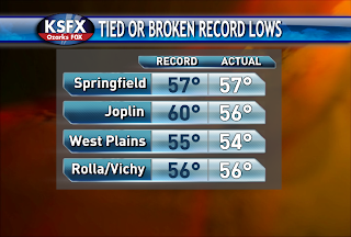
Morning lows were broken or tied!
West Plains and Rolla/Vichy stand another chance of breaking a record low tonight.

HEAVY RAINFALL POTENTIAL ON TUESDAY

The image above shows the predicted amount of rain that could fall between Monday and Tuesday evening. 1-2" of rain is possible across SW Missouri, SE Kansas, NE Oklahoma and NW Arkansas. The least amount of rain is forecast to fall across the eastern half of the Ozarks. If the track of the system shifts further eastward then the heavier amounts will as well.

Saturday, July 18, 2009

RECORD LOWS

Here is a chart of the record lows and the forecast lows for tonight/Sunday morning. Most places stand a good chance of breaking the old record low by a degree or two. Clouds and higher dewpoint readings would be the only factors that could stand in the way of this happening. Clouds act like a blanket and keep heat in at night. The air temperature can never drop below the dewpoint temperature.
The normal high for this time of year is 90 degrees and highs in the lower 80s are likely on Sunday.

EARLY IN THE WEEK

Our next system will be brewing to our west on Monday. The question is which track will the system take??? Models differ "big time" right now. One model shows the rain only grazing the western half of the Ozarks on Tuesday while the other shows a good chance for rain and storms everywhere. For now, I'm leaning towards the drier forecast. Keep checking in for further updates!

Friday, July 17, 2009

Mid-Summer Cool Snap!

A high pressure system from Canada will send our overnight lows this weekend to record-breaking territory. The forecast for Saturday morning is 54 and the record is 53. Sunday morning is being pegged at 53 and the record is presently 57.

Meanwhile, daytime highs will barely get to 80 both weekend days. Dew points will be in the fifties which is very dry and comfortable air for summer. Enjoy!

Wednesday, July 15, 2009

Cool Weekend

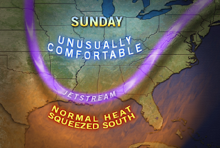
A shift in the jet stream will allow cooler air to flow in from Canada this weekend along woth lower humidity. Lows will drop into the fifties both Saturday and Sunday morning while highs will stay in the lower and middle eighties. Record lows may be threaten on these two days especially Sunday morning. Here's a list of the records:

Saturday the 18th: 53 in 1984
Sunday the 19th: 57 in 1984

Weather Watch Hoisted

A severe thunderstorm watch has been posted for areas from Springfield east and south for Wednesday afternoon and evening. Downburst damaging winds and isolated large hail may occur in the this region. The left over spinning from a storm cluster last night will provide additional focus for storm in this area.