MSU Storm Chase Class

Wednesday, August 19, 2009

Severe Update


It is possible for an extention of the tornado warning into northwestern Greene and southern Polk.

Ted Keller
Senior Meteorologist
KOLR/KSFX-TV
Storm chasing and more at:
Ceaseless Wind
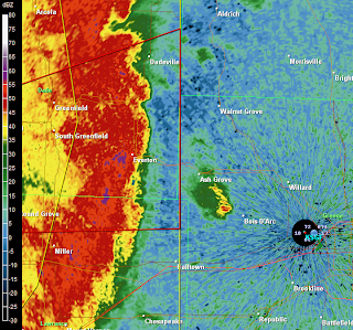
Severe Weather Update


Line segment is bowing and will likely produce 70 mph winds from Joplin to Lamar over the next 45 minutes.

Ted Keller
Senior Meteorologist
KOLR/KSFX-TV
Storm chasing and more at:
Ceaseless Wind

Flash Flood Watch

A flash flood watch has just issued for tonight and early Thursday for a portion of the viewing area. The watch is in effect for folks living north of a line from around Neosho to Eminence, Missouri.

Portions of Hickory, St. Clair, Benton, Polk, Camden and Dallas Counties have received pretty heavy rains the past two Mondays and would be the most prone to flash flooding.

The good news is this front will make a clean sweep of the area by Thursday afternoon and set us up for a fantastic Friday through Sunday!


Ted Keller
Senior Meteorologist
KOLR/KSFX-TV
Storm chasing and more at:
Ceaseless Wind

Tuesday, August 18, 2009

More Rain, Severe Storms?


Yet another Summer 2009 front will work through the area starting Wednesday evening. With it, bands of showers ansd storms will lay down locally heavy rainfall. The area north of the line from Lamar to Salem will receive on average over an inch of rain with the Lake of the Ozarks area perhaps averaging closer to two inches. There is also a chance for severe storms with this front especially northwest of Springfield. This front drives temperatures back down for the weekend; look for lows in the fifties and highs averaging around eighty.


Ted Keller
Senior Meteorologist
KOLR/KSFX-TV
Storm chasing and more at:
Ceaseless Wind

Monday, August 17, 2009

Rainfall Today


This is a radar estimate of rain today.

Ted Keller
Senior Meteorologist
KOLR/KSFX-TV
Storm chasing and more at:
Ceaseless Wind

Hurricane Camille


Today is the anniversary of the landfall of Hurricane Camille, a category five storm which made landfall on the Mississippi coast in 1969.

Until the Karina disaster, Camille was the example of what a "worst case" gulf storm and the damage capable of producing.

Ted Keller
Senior Meteorologist
KOLR/KSFX-TV
Storm chasing and more at:
Ceaseless Wind

Ana and Bill


Tropical depression "Ana" has an uphill battle for strengthening over the next few days.

First, the system is weak and barely recognized as a closed-off low at the surface. Any organization Ana might try to gain would be wiped out by interactions with the mountains of the Dominican Republic, Haiti and Cuba. NOTE: NHC is downgraded this system to a trough a low pressure as of late this afternoon.

It is also in dry air in the middle levels of the atmosphere which makes sustained thunderstorm development very difficult.

Latest computer model guidance do have what's left of Ana emerging into the Gulf of Mexico late this week. It is at least plausible that this could reform into a stronger tropical system at this time.

Bill on the other hand is forecast to strengthen into a major hurricane over the next few days. But it really appears has if this storm will start its curve out over the Atlantic before it has a shot at the eastern U.S. The island of Bermuda will have to what Bill this weekend.

Note the the upper level winds later this week would be out of the northwest over the Ozarks so there is virtually no chance of any of these tropical systems affecting us with their rainfall.


Ted Keller
Senior Meteorologist
KOLR/KSFX-TV
Storm chasing and more at:
Ceaseless Wind