MSU Storm Chase Class

Wednesday, March 25, 2009

Heavy Rain Potential

The image is the Hydrological Prediction Center's 1-3 precipitation total ending at 7 pm Saturday. One large batch of rain is due in Thursday evening into early Friday. More is due late Friday and early Saturday. There is still a possibility of some snow mixing in with this over the area on Saturday. There does appear to be a chance for accumulating snow in areas northwest of Springfield. Computer models are differing on this storm, watch the Weather Lab for updates!

Tuesday, March 24, 2009

Next Big Storm


The next big storm will see us between an outbreak of severe weather to the southeast on Friday and a band of accumulating snow late Friday and Saturday. We will see lots of rain Friday and a few storms. On Saturday, there is a possibility that showers will be mixed with or change over to wet snow!

Severe Storm Chances Today!!!


IMAGE AS OF 12:08PM ON TUESDAY, MARCH 24.

Strong to severe storms will impact the Ozarks from west to east this afternoon. Some of the storms may produce winds in excess of 60 mph, quarter size hail and brief spin ups. The other and more dangerous hazards from these storms is heavy rainfall which is leading to flash flooding. Roads are becoming impassable, especially near low water crossings. Don't attempt to cross a road that is flooded. There is a severe thunderstorm watch in effect across parts of the Ozarks along with a wind advisory until 4pm.


SEND STORM REPORTS, PICTURES & VIDEOS TO WEATHERLAB@OZARKSFIRST.COM.

Monday, March 23, 2009

Storm Update

Storms have fired in Kansas and Oklahoma. One cell produced a few tornado reports as it passed south of Wichita earlier. The area in the oval above will form a squall line which will approach areas far to the northwest of Springfield overnight tonight.

Meanwhile, a few isolated storms may fire in southwest Missouri this evening but will stay below severe limits.

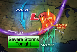
Severe Storms Tonight


The Ozarks will find themselves on the edge of some severe thunderstorms late tonight. Storms will fire over central Oklahoma and Kansas, form a line, and then move northeast, impacting areas to the west and north of Springfield after midnight. All forms of severe weather are possible with these storms including the possibility of tornadoes.

Another update will be posted at 6:35 this evening. Please watch the 5 and 6 o'clock news on KOLR-10 for the latest and make sure to tune into the Weather Lab when the weather turns severe!

WIND ADVISORY

A WIND ADVISORY IS IN EFFECT TODAY

Strong and gusty southerly winds have developed today. Sustained winds of 25-35 mph with gusts to 45 mph can be expected generally along and west of highway 65. Winds this strong can make driving difficult especially for high profile vehicles. Drive with caution!

Saturday, March 21, 2009

SEVERE STORMS POSSIBILITY


A powerful storm system will cause strong to severe storms to develop across Oklahoma, Kansas and Nebraska on Monday afternoon. Those storms will likely continue overnight along a surging cold front across portions of the mid and lower Missouri valleys and perhaps into the Ozarks Plateau. All modes of severe weather are possible on Monday nt-Tuesday morning, however, the primary hazards look to be large hail and damaging winds at this time. Storms will be strongest across western Missouri and Arkansas and will have the tendency to weaken as they track eastward across the Ozarks during the late morning hours and early afternoon hours on Tuesday. Severe weather will still be a possibility though I think the concern will shift towards flash flooding. We could receive 1-2" of rain with locally higher amounts.