MSU Storm Chase Class

Sunday, April 19, 2009

Flooding Concerns Today...


A flood advisory means river or stream flows are elevated or ponding of water in urban and other areas is occurring or is imminent.

A flood warning means that flooding is immenent or has been reported. Stream rises will be slow and flash flooding is not expected. All interested parties should take necessary precautions immediately though.


Saturday, April 18, 2009

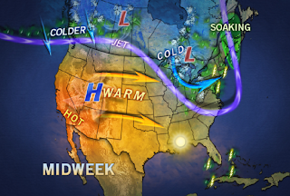
Pattern Change This Week!

We end the weekend and start off the week with cooler than normal temperatures. While this is going on, a big warm up is taking place to our west. The warmer than normal air is expected to take over beginning on Wednesday. Gulf moisture is also going to be increasing by the end of the week, which will result in warmer overnight lows.

Severe Storms on Saturday


A severe thunderstorm watch in in effect until 12am.

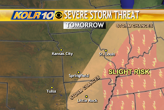
There is a slight risk for severe storms across southwest Missouri and northwest Arkansas. Large hail and damaging winds in excess of 60 mph are the main threats from the severe storms that develop. An isolated tornado cannot be ruled out. Heavy rainfall and frequent cloud to ground lightning can also be expected from these storms.

Storm reports so far today:
-Hail 1-1.5" in diameter. City: Noel County: McDonald

-Hail .88". City: Anderson County: McDonald

-Strong winds blow down several buildings in Anderson at the intersection of 76 and 59.

-Flash flooding is possible in Jasper and Newton county. Radar estimated rainfall of 1 and 1/2 inches has already fallen across those counties.
- 1.31" of rain about 5 miles south of Flemington in northern Polk county.

Wednesday, April 15, 2009

OUR NEXT RAIN MAKER...

The upper level low near the four corners region will gradually approach the Ozarks from the west as we head into the weekend. It will cause Gulf moisture to increase out ahead of it along with shower and thunderstorm clusters. Rain chances are not expected to go up until Friday night and mainly across southwest Missouri. It may take until Saturday morning for rain chances to spread eastward across the rest of the Ozarks and Arkansas.

Monday, April 13, 2009

Next Batch of Rain/Storms

A large storm in the upper atmosphere will eventually bring rain and thunderstorms back to the Ozarks, perhaps as early as Friday night and then on Saturday through Monday. This storm looks as if it will hang back most of the work week, allowing warmer temperatures to develop out ahead of it. This should translate to at least one seventy-degree day by Thursday, Friday or perhaps both days.

Some Frost Tonight

An opportunity for frost to form tonight exists for folks to the rest of Springfield. This is an area which is expected to having clearing skies first tonight which will allow temperatures to drop to near the level of frost.

Sunday, April 12, 2009

UPPER LEVEL LOW IMPACTS

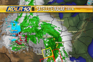
As of 3pm on Sunday, an upper level low that is currently positioned across the panhandle of Texas is forecast to continue tracking east and at times northeastward across the state of Missouri. We'll experience showers and steady rains from this system and perhaps some thunder tonight.
The upper level system will spark strong to severe storms on Monday afternoon to the east and southeast of the Ozarks.

Thunderstorms remain in the forecast on Monday, mainly to the east of Springfield and Lebanon. These storms again are not expected to be severe.