MSU Storm Chase Class

Wednesday, June 3, 2009

DRIER WEATHER ON THURSDAY

High pressure brings cooler and drier weather to the Ozarks on Thursday. Dewpoints in the lower 50s and upper 40s take over for a day, which will make it feel comfortable outside. Northeasterly winds will also prevent temperatures from warming above the lower to middle 70s. Overall, it will be cool to start and pleasant during the afternoon hours. Let the refreshing air in, because it's going to be heating up again over the weekend!

A LOOK AHEAD AT THE WEEKEND

We warm up ahead of the next approaching storm system. Temperatures and dewpoints will both be increasing over the weekend which will result in afternoon instability. Isolated showers and storms can't be ruled out, however, a warm lid aloft should prevent widespread development. Most places should stay dry and heat up into the middle and upper 80s.

Tuesday, June 2, 2009

Severe storms & Flash flooding

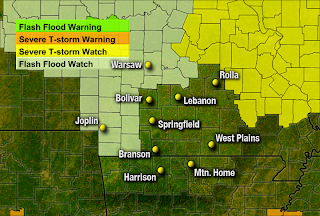
Flash flood watch remains in effect from 7pm this evening through Wednesday evening.
A frontal boundary pushes into the Ozarks tonight.
Thunderstorms will continue to develop along the front and behind it.

Some of the storms initially may be severe. Hail and damaging wind gusts are the main threats.

Heavy showers and storms continue to impact the Ozarks on Wednesday.

Along and to the east of I-44 1-2" of rain is expected with locally higher amounts.

Sunday, May 31, 2009

2009 Atlantic Hurricane Season Forecast

Forecasters are predicting and normal hurricane season this year.


Last year, we got a taste of two tropical systems named Gustav and Ike. Inland tropical systems are most known for producing flooding rains and on occasion strong gusty winds.

Very Warm Monday

June begins above normal! Highs in the upper 80s will be common across the Ozarks on Monday. If you work outside; make sure to wear light weight and light colored clothing, take breaks in the shade and drink plenty of water. If you plan on going for a run, the best times to do it is before 10 am and after 5pm.

Storminess by midweek

The Storm Prediction Center posted a slight risk for severe storms on Tuesday. The slight risk area grazes the northwestern portion of the viewing area. Most of the storms that develop will avoid the Ozarks, but will need to be watched closely. Overall, there is about a 30% chance for thunderstorms from Nevada to Warsaw during Tuesday afternoon. Rain and storms become likely at night and spread southeastward across the Ozarks.
A disturbance/front tracks across the Ozarks on Wednesday. Scattered showers and storms are likely. Severe weather is NOT expected at this time. Make sure to check in for further updates early in the week.

Saturday, May 30, 2009

UV-Index Forecast and Explanation

Accuweather computer models are predicting a UV-INDEX around 8 in the Ozarks for tomorrow afternoon. An index of 8 means a very high risk of harm from unprotected sun exposure. It's a good idea to wear sunscreen, a shirt, sunglasses, and a hat. Don't stay out in the sun for too long.


For more information visit this website