 Arkansas remains under a WINTER WEATHER ADVISORY until 3am. If you must drive tonight, drive slowly!
Saturday, February 28, 2009
WINTER STORM WARNING/ADVISORY UPDATE
 Arkansas remains under a WINTER WEATHER ADVISORY until 3am. If you must drive tonight, drive slowly!
Friday, February 27, 2009
The Snow of the Season!


One band of enhanced snow will enter central Missouri and then fade a bit. A second maximum area will develop over south-central Missouri by afternoon and spread east toward the bootheel.
Thursday, February 26, 2009

A supercell thunderstorm began to take shape in St Clair Co during the evening of February 26th.
It had good radar structure as it moved ESE through northern Polk Co. As it entered Dallas Co., it began to show signs of stronger rotation and the National Weather Service issued a tornado warning at about 6:15 pm.
The yellow callouts are wind damge reports and the green are hail reports.
The circulation center passed south of Lebanon.
WIND REPORTS
6:20 PM: LOUISBURG,MO, DALLAS CO.
ESTIMATED 50 MPH WIND GUST
6:30 PM: 2 NW WINDYVILLE,MO, DALLAS CO.
2 FT DIAMETER TREE DOWN BETWEEN PLAD AND WINDYVILLE OFF OF HWY K.
6:38 PM: BENNETT SPRINGS,MO, LACLEDE CO.
LARGE BILLBOARD PUSHED OVER BY WINDS.
7:22 PM: 5 SE FALCON, MO, CO.
PUBLIC REPORT OF 4 INCH DIAMETER TREE LIMBS BROKEN ON HIGHWAY 32
7:25 PM, FALCON, MO, LACLEDE CO.
WIND GUST ESTIMATED TO 70 MPH
Storm Potential Update

Tuesday, February 24, 2009
SEVERE STORM THREAT THURSDAY
 Storms are forecast to form in Illinois and areas to the northeast and then build southwestward along the cold front during the late afternoon and evening hours. There is a slight risk for severe storms today. The main threats would be damaging winds and hail. The chance for an isolated tornado or two cannot be ruled out. There is still a lot of question as to whether or not supercells will even form. The greatest chance for surface-based storms is across Arkansas, except for the NW corner. We'll continue to monitor this situation as it unfolds.
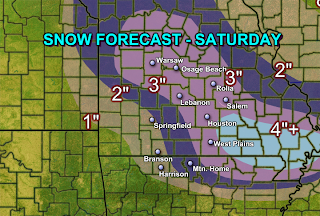
SNOW FOR THE 3RD WEEKEND IN A ROW?
 The images above show total liquid forecast amounts for Saturday. Notice how the computer models do not agree on amounts but do agree on the general track of precipitation. Converting liquid amounts over to snow with each model, the general consensus is that the heaviest snow will fall east of Springfield or north.
 GFS converted: 1" or less might fall in a line from Joplin to Branson to Mtn Home and points south. 2" is possible points north including Nevada, Springfield, West Plains and Osage Beach. Greater than 2" is possible in Lebanon to Rolla to Salem. Isolated amounts around 4" if possible in parts of eastern Dent and Shannon counties.
NAM converted" 1" or less is forecast across Nevada to Joplin to Branson to Mtn Home and points south. 2" is forecast to fall across Springfield to Osceola to West Plains. Greater than 2" is possible across Houston to Lebanon to Osage Beach to Warsaw.


